Burgerveen
Appearance
52°14′N 4°41′E / 52.233°N 4.683°E
Burgerveen | |
|---|---|
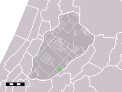
 The hamlet (darkgreen) and the statistical district (lightgreen) of Burgerveen in the municipality of Haarlemmermeer. | |
 | |
| Country | Netherlands |
| Province | North Holland |
| Municipality | Haarlemmermeer |
| Population (January 2008 [1]) | 374 |
Burgerveen is a hamlet in the western Netherlands. It is located in the municipality of Haarlemmermeer, North Holland, about halfway between Amsterdam and The Hague.
In 2001, the built-up area of Burgerveen had 215 inhabitants in 90 housing units on 0.06 km².[2] The wider statistical area of Burgerveen has a population of around 300.[3]
Born in Burgerveen
- Hendrikus Colijn (1869–1944), twice prime minister of the Netherlands.
References
- ^ Aantal inwoners per woonkern[permanent dead link]. Ons-Haarlemmermeer.nl, 5 november 2008
- ^ Statistics Netherlands (CBS), Bevolkingskernen in Nederland 2001 "Archived copy". Archived from the original on 2006-03-19. Retrieved 2007-01-24.
{{cite web}}: Unknown parameter|deadurl=ignored (|url-status=suggested) (help)CS1 maint: archived copy as title (link). Statistics are for the continuous built-up area. - ^ Statistics Netherlands (CBS), Gemeente Op Maat 2004: Haarlemmermeer [1][permanent dead link].
