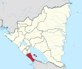
Cárdenas, Nicaragua
Appearance
(Redirected from Cárdenas, Rivas)
This article needs additional citations for verification. (September 2024) |
Cárdenas | |
|---|---|
Municipality | |
| Coordinates: 11°12′N 85°31′W / 11.200°N 85.517°W | |
| Country | |
| Department | Rivas Department |
| Area | |
| • Land | 88 sq mi (227 km2) |
| Population | |
| • Municipality | 6,990 |
| • Urban | 934 |
Cárdenas is a municipality in the Rivas department of Nicaragua, located on the southwestern shore of Lake Nicaragua.
In 2002, the municipality of Cárdenas had threatened the government in Managua with secession and becoming part of Costa Rica. Costa Rica claimed that it would respect Nicaraguan territory and had no intention of annexing the municipality. [1]
Climate
[edit]| Climate data for Cárdenas, Nicaragua (1971–1990) | |||||||||||||
|---|---|---|---|---|---|---|---|---|---|---|---|---|---|
| Month | Jan | Feb | Mar | Apr | May | Jun | Jul | Aug | Sep | Oct | Nov | Dec | Year |
| Mean daily maximum °C (°F) | 27.8 (82.0) |
28.8 (83.8) |
30.6 (87.1) |
31.5 (88.7) |
31.4 (88.5) |
29.6 (85.3) |
28.9 (84.0) |
29.1 (84.4) |
29.3 (84.7) |
29.1 (84.4) |
28.6 (83.5) |
27.9 (82.2) |
29.4 (84.9) |
| Daily mean °C (°F) | 25.2 (77.4) |
25.8 (78.4) |
26.9 (80.4) |
27.5 (81.5) |
27.3 (81.1) |
26.6 (79.9) |
26.3 (79.3) |
26.4 (79.5) |
26.3 (79.3) |
26.2 (79.2) |
26.0 (78.8) |
25.5 (77.9) |
26.3 (79.3) |
| Mean daily minimum °C (°F) | 22.6 (72.7) |
22.8 (73.0) |
22.9 (73.2) |
23.7 (74.7) |
23.8 (74.8) |
23.6 (74.5) |
23.6 (74.5) |
23.6 (74.5) |
23.3 (73.9) |
23.2 (73.8) |
23.3 (73.9) |
23.0 (73.4) |
23.3 (73.9) |
| Average precipitation mm (inches) | 40 (1.6) |
19 (0.7) |
18 (0.7) |
41 (1.6) |
153 (6.0) |
345 (13.6) |
303 (11.9) |
257 (10.1) |
351 (13.8) |
340 (13.4) |
184 (7.2) |
70 (2.8) |
2,121 (83.5) |
| Average precipitation days (≥ 1.0 mm) | 8 | 4 | 3 | 4 | 13 | 21 | 20 | 19 | 21 | 21 | 14 | 12 | 160 |
| Source: National Oceanic and Atmospheric Administration[1] | |||||||||||||
References
[edit]- ^ "Station Name: CARDENAS" (TXT). National Oceanic and Atmospheric Administration. Retrieved 21 September 2024.
11°12′N 85°31′W / 11.200°N 85.517°W


