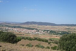
Calamocha
Appearance
Calamocha | |
|---|---|
 | |
| Coordinates: 40°55′2″N 1°18′0″W / 40.91722°N 1.30000°W | |
| Country | Spain |
| Autonomous community | Aragon |
| Province | Teruel |
| Comarca | Jiloca Comarca |
| Government | |
| • Mayor | Manuel Rando López (PSOE de Aragón) (2015–2019) |
| Area | |
| • Total | 316.63 km2 (122.25 sq mi) |
| Population (2015) | |
| • Total | 4,417 |
| • Density | 14/km2 (36/sq mi) |
| Demonym | Calamochino |
| Time zone | UTC+1 (CET) |
| • Summer (DST) | UTC+2 (CEST) |
Calamocha is a town and municipality of Teruel province in the autonomous community of Aragon, Spain. In 2015 the municipality had a population of 4,417 inhabitants.
Calamocha is the administrative centre of the Aragonese comarca of Jiloca.
Villages
As well as the town of Calamocha itself, the following villages and hamlets form part of the municipality:
- Collados
- Cuencabuena
- Cutanda
- Lechago
- Luco de Jiloca
- Navarrete del Río
- Nueros
- Olalla
- El Poyo del Cid
- Valverde
- Villarejo de los Olmos
References
External links
Wikimedia Commons has media related to Calamocha.


