
Caledonia, Kentucky
Caledonia | |
|---|---|
 Caledonia Location within the state of Kentucky  Caledonia Caledonia (the United States) | |
| Coordinates: 36°49′13″N 87°41′42″W / 36.82028°N 87.69500°W | |
| Country | United States |
| State | Kentucky |
| County | Trigg |
| Elevation | 459 ft (140 m) |
| Time zone | UTC-6 (Central (CST)) |
| • Summer (DST) | UTC-5 (CST) |
| GNIS feature ID | 507638[1] |
Caledonia is an unincorporated community in Trigg County, Kentucky, United States. It was also known as Cherryville.
References
Municipalities and communities of Trigg County, Kentucky, United States | ||
|---|---|---|
| City | 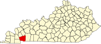 | |
| CDP | ||
| Other unincorporated community | ||
| Ghost town | ||
| Footnotes | ‡This populated place also has portions in an adjacent county or counties | |
This Trigg County, Kentucky state location article is a stub. You can help Wikipedia by expanding it. |