
California station (CTA Congress Line)
California | ||||||||||||||||
|---|---|---|---|---|---|---|---|---|---|---|---|---|---|---|---|---|
 | ||||||||||||||||
| General information | ||||||||||||||||
| Location | 430 South California Avenue Chicago, Illinois 60612 | |||||||||||||||
| Coordinates | 41°52′31″N 87°41′47″W / 41.8754°N 87.6964°W | |||||||||||||||
| Owned by | Chicago Transit Authority | |||||||||||||||
| Line(s) | Congress-Milwaukee Line | |||||||||||||||
| Platforms | 1 island platform | |||||||||||||||
| Tracks | 2 | |||||||||||||||
| History | ||||||||||||||||
| Opened | June 22, 1958 | |||||||||||||||
| Closed | September 2, 1973 | |||||||||||||||
| Services | ||||||||||||||||
| ||||||||||||||||
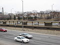
California is an abandoned rapid transit station in the East Garfield Park neighborhood of Chicago, Illinois. The station served the Chicago Transit Authority's Congress Line, which is now part of the Blue Line. California opened on June 22, 1958, and closed on September 2, 1973, as part of a group of budget-related CTA station closings.[1][2]
Image Gallery
-
 Station platform

References
- ^ Garfield, Graham. "California". Chicago-L.org. Retrieved May 9, 2009.
- ^ Buck, Thomas (September 2, 1973). "CTA Shutting Down 7 Rapid Transit Stations Today". Chicago Tribune. p. 5.
External links