Campo de Robledo
Appearance
Campo de Robledo | |
|---|---|
 Location in Salamanca | |
| Coordinates: 40°28′0″N 6°35′59″W / 40.46667°N 6.59972°W | |
| Country | Spain |
| Autonomous community | Castile and León |
| Province | Salamanca |
| Comarca | Comarca de Ciudad Rodrigo |
| Area | |
| • Total | 550.84 km2 (212.68 sq mi) |
| Population (2010) | |
| • Total | 3,597 |
| • Density | 6.5/km2 (17/sq mi) |
| Time zone | UTC+1 (CET) |
| • Summer (DST) | CEST |
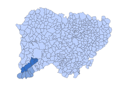
Campo de Robledo is a subcomarca in the comarca of Comarca de Ciudad Rodrigo in the province of Salamanca, Castile and León. It contains five municipalities: El Bodón, Casillas de Flores, La Encina, Fuenteguinaldo and Pastores.[1]
References
[edit]- ^ Llorente Maldonado, Antonio (1976). Centro de Estudios Salmantinos, ed. Las comarcas históricas y actuales de la provincia de Salamanca. p. 157.
