Jump to content

Capela, Alagoas

Coordinates: 09°24′27″S 36°04′25″W / 9.40750°S 36.07361°W / -9.40750; -36.07361
From Wikipedia, the free encyclopedia

This is an old revision of this page, as edited by InternetArchiveBot (talk | contribs) at 15:35, 14 November 2016 (Rescuing 1 sources and tagging 0 as dead. #IABot (v1.2.7.1)). The present address (URL) is a permanent link to this revision, which may differ significantly from the current revision.

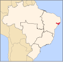
Capela is a municipality located in the Brazilian state of Alagoas. Its population is 18,640 (2005) and its area is 205 km².[1]

References

  1. ^ IBGE - "Archived copy". Archived from the original on 2008-06-11. Retrieved 2008-06-11. {{cite web}}: Unknown parameter |deadurl= ignored (|url-status= suggested) (help)CS1 maint: archived copy as title (link)

09°24′27″S 36°04′25″W / 9.40750°S 36.07361°W / -9.40750; -36.07361