
Carrick Roads
This article needs additional citations for verification. (January 2010) |
Carrick Roads (Cornish: Dowr Carrek) is located on the southern Cornish coast in England, UK, near Falmouth. It is a large waterway created after the Ice age from an ancient valley which flooded as the melt waters caused the sea level to rise dramatically (see Ria), creating a large natural harbour which is navigable from Falmouth to Truro.
The Falmouth Harbour Commissioners[1] are the statutory port authority with responsibility for the Inner Harbour at Falmouth (excluding Falmouth Docks), the Penryn River up as far as Boyers Cellars, the southern part of the Carrick Roads and a large part of Falmouth Bay.
The Roads are crossed by the historic and scenic King Harry Ferry, a vehicular chain ferry that links the parishes of Feock and Philleigh.
Carrick Roads is named after Black Rock (Cornish: Karrek Reun, meaning seal rock) which lies between Pendennis Point, St Mawes, and Carricknath Point.
Gallery
-

-
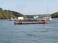 Carrick Roads near Trelissick
 -
 An aerial view showing Carrick Roads, Truro and Falmouth
 -
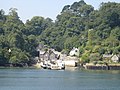 The Feock terminal of the King Harry Ferry in 2005


References
- ^ "Falmouth Harbour Commissioners Home". Falmouthport.co.uk. Retrieved 2012-02-04.
50°09′12″N 5°02′08″W / 50.15333°N 5.03556°W
This Cornwall location article is a stub. You can help Wikipedia by expanding it. |