Causses
| UNESCO World Heritage Site | |
|---|---|
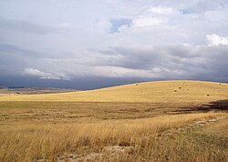
 Causse Méjean in Massif Central, Cévennes National Park, France | |
| Criteria | Cultural: iii, v |
| Reference | 1153 |
| Inscription | 2011 (35th Session) |


The Causses are a group of limestone plateaus (700–1,200 m) in the Massif Central. They are bordered to the north-west by the Limousin and the Périgord uplands, and to the east by the Aubrac and the Cévennes. Large river gorges cut through the plateau, such as the Tarn, Dourbie, Jonte, Lot and Aveyron. Causse is an Occitan word meaning "limestone plateau".
Arranged from the north-west to the south-east, the following plateaus are found:
- the Causses du Quercy:
- the Causse de Martel (Lot)
- the Causse de Gramat (Lot)
- the Causse de Limogne (Lot)
- the Causse corrèzien (Corrèze)
- the Grands Causses:
- the Causse du Comtal (Aveyron)
- the Causse de Sévérac (Aveyron)
- the Causse de Sauveterre (Lozère)
- the Causse Méjean (Lozère)
- the Causse Noir (Aveyron)
- the Causse Rouge (Aveyron)
- the Causse du Larzac (Aveyron and Hérault)
Many sites on the Causses are included in Natura 2000, notably the Parc Naturel Régional des Grands Causses on the Larzac, Méjean, and Noir plateaus. The Causses and the Cévennes, Mediterranean agro-pastoral Cultural Landscape was added to the UNESCO World Heritage list in 2011.[1]
References
External links
44°9′N 3°15′E / 44.150°N 3.250°E
