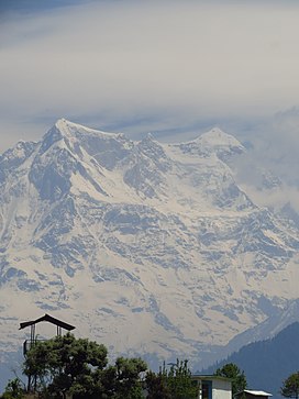
Chaukhamba
| Chaukhamba I | |
|---|---|
 Chaukhamba peak as seen from Deoria Tal/Lake in Chandrashila peak | |
| Highest point | |
| Elevation | 7,138 m (23,419 ft)[1] |
| Prominence | 1,594 m (5,230 ft)[2] |
| Listing | Ultra |
| Coordinates | 30°44′59″N 79°17′28″E / 30.74972°N 79.29111°E[3] |
| Geography | |
| Location | Uttarakhand, India |
| Parent range | Gangotri Group, Garhwal Himalaya |
| Climbing | |
| First ascent | 13 June 1952, by Lucien George and Victor Russenberger[3][4] |
Chaukhamba is a mountain massif in the Gangotri Group of the Garhwal Himalaya. Its main summit, Chaukhamba I, is the highest peak in the group. It lies at the head of the Gangotri Glacier and forms the eastern anchor of the group.[5] It is located in the northern Indian state of Uttarakhand, west of the Hindu holy town of Badrinath.
Chaukhamba has four summits, along a northeast-southwest trending ridge, and ranging in elevation from 7,138 metres (23,419 ft) to 6,854 m (22,487 ft) with an average elevation 7,014 m;[3] the main summit is at the northeast end.
| Chaukamba I | 7,138 m (23,419 ft) |
| Chaukamba II | 7,070 m (23,196 ft) |
| Chaukamba III | 6,995 m (22,949 ft) |
| Chaukamba IV | 6,854 m (22,487 ft) |

After unsuccessful attempts in 1938 and 1939, Chaukhamba I was first climbed on 13 June 1952, by Lucien George and Victor Russenberger (Swiss members of an otherwise French expedition). They ascended the northeast face, from the Bhagirathi-Kharak Glacier.[4]
Chaukhamba I is an ultra-prominent peak, with a prominence of more than 1,500m. Mana Pass is the key col for Chaukhamba I.

Photo gallery
-
Chaukhamba from Tungnath
-
Chaukhamba from Tungnath shortly after sunrise
-
Moonlit Chaukhamba from the Kartikswamy temple
See also
References
- ^ IMF Archived 11 October 2008 at the Wayback Machine
- ^ "High Asia I: The Karakoram, Pakistan Himalaya and India Himalaya (north of Nepal)". Peaklist.org. Retrieved 28 May 2014.
- ^ a b c Himalayan Index
- ^ a b American Alpine Journal, 1953, pp. 581-582.
- ^ Andy Fanshawe and Stephen Venables, Himalaya Alpine-Style, Hodder and Stoughton, 1995, ISBN 0-340-64931-3, p. 106.
External links
- Archived 2008-10-11 at the Wayback Machine
- View of Chaukhamba peak during the Chopta/Chandrashila trek at the Wayback Machine (archived 2011-08-23)


