
Chungará Lake
| Lake Chungará | |
|---|---|
 Lake and Parinacota Volcano | |
| Location | Arica y Parinacota Region, Chile |
| Coordinates | 18°15′S 69°09′W / 18.250°S 69.150°W |
| Primary inflows | Chungará, Sopocalane |
| Basin countries | Chile |
| Surface area | 21.5 square kilometres (8.3 sq mi) |
| Max. depth | 33 metres (108 ft) |
| Surface elevation | 4,517 metres (14,820 ft) |
Chungará (hispanicized spelling of Aymara chunkara "pointed mountain")[1] is a lake situated in the extreme north of Chile, in the Altiplano of Arica y Parinacota Region in the Lauca National Park. It is the 31st highest lake in the world (and the 12th highest in South America).[2] It is near the volcanos Parinacota (20,827 ft or 6,348 m) and Pomerape (20,413 ft or 6,222 m).[3] It was formed 8000 years ago, when a major collapse of the edifice of Parinacota produced an avalanche of 6 km³ of debris which blocked drainage pattern, thus creating the lake.
The pencil catfish Trichomycterus chungarensis and the pupfish Orestias chungarensis are endemic to the lake basin.
-
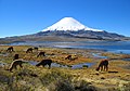 Vicuñas at Chungará Lake
 -
 Parinacota Volcano and Lake Chungará
 -
 Morning on Chungará Lake.


See also
References
- ^ "Diccionario Bilingüe Castellano-Aymara 2002". Félix Laime Pairumani. Archived from the original on September 23, 2015. Retrieved January 14, 2015.
{{cite web}}: Unknown parameter|deadurl=ignored (|url-status=suggested) (help) - ^ [1]
- ^ "Archived copy". Archived from the original on 2006-04-05. Retrieved 2006-03-31.
{{cite web}}: Unknown parameter|deadurl=ignored (|url-status=suggested) (help)CS1 maint: archived copy as title (link)
| Rivers | ||
|---|---|---|
| Lakes | ||
This Chile location article is a stub. You can help Wikipedia by expanding it. |