
Claremont Landscape Garden
| Claremont Landscape Garden | |
|---|---|
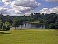
 Lake and amphitheatre (left) | |
| Official name | Claremont |
| Designated | 1 June 1984 |
| Reference no. | 1000324[1] |
Claremont Landscape Garden, just outside Esher, Surrey, England, is one of the earliest surviving gardens of its kind of landscape design, the English Landscape Garden — still featuring its original 18th-century layout. The garden is Grade I listed on the Register of Historic Parks and Gardens.[1]
History
Originally created for Claremont House, it represents the work of some of the best known landscape gardeners, such as Charles Bridgeman, Capability Brown, William Kent and Sir John Vanbrugh.
Work on the gardens began around 1715 and by 1727 they were described as "the noblest of any in Europe". Within the grounds, overlooking the lake, is an unusual turfed amphitheatre, which used to form the centrepiece of an annual event called the Claremont Fête champêtre. Hundreds of visitors descended on Claremont, most in costume (each year has a different theme) to enjoy four days of music, theatre and fireworks.
Stewardship
Also within the grounds is the Belvedere Tower, designed by Sir John Vanbrugh for the Duke of Newcastle. The tower is unusual in that what appear to be windows, are actually bricks painted black and white. It is now owned by Claremont Fan Court School, which is situated alongside the gardens.
In 1949 the landscape garden was donated to the National Trust for stewardship and protection. A restoration programme was launched in 1975 following a significant donation by the Slater Foundation.
Gallery
-
 Claremont lake
 -
 Belvedere Tower

Transport
- See also the A307, Portsmouth Road.
Bibliography
- Turner, Roger, Capability Brown and the Eighteenth Century English Landscape, 2nd ed. Phillimore, Chichester, 1999, pp. 115– 118.
See also
References
- ^ a b Historic England, "Claremont (1000324)", National Heritage List for England, retrieved 10 February 2016