
Clarenceville station (LIRR)
Clarenceville | ||||||||||||||||
|---|---|---|---|---|---|---|---|---|---|---|---|---|---|---|---|---|
 1891 map of Clarenceville station | ||||||||||||||||
| General information | ||||||||||||||||
| Location | Atlantic Avenue west of 111th Street, Richmond Hill, New York | |||||||||||||||
| Coordinates | 40°41′31.2″N 73°50′07.2″W / 40.692000°N 73.835333°W | |||||||||||||||
| Owned by | LIRR | |||||||||||||||
| Line(s) | ||||||||||||||||
| Platforms | 2 side platforms | |||||||||||||||
| Tracks | 2 | |||||||||||||||
| Other information | ||||||||||||||||
| Station code | None | |||||||||||||||
| Fare zone | 1 | |||||||||||||||
| History | ||||||||||||||||
| Opened | 1874 | |||||||||||||||
| Closed | 1939 | |||||||||||||||
| Electrified | 1905 | |||||||||||||||
| Services | ||||||||||||||||
None
Template:S-line-loc
| ||||||||||||||||
Clarenceville Station was a station on the Atlantic Branch, which ran along Atlantic Avenue, of the Long Island Rail Road, located west of 111th Street in the Richmond Hill section of Queens, New York City.[1] Richmond Hill Station to the north, at Jamaica Avenue and Lefferts Boulevard, was also originally named Clarenceville Station when it opened in 1868, but that name was changed in 1871.
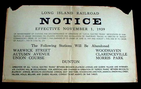
Clarenceville was originally an 1874-built Atlantic Avenue Rapid Transit station that was reopened as an LIRR station in 1905 as part of the LIRR's electrification of the Atlantic Branch, and closed in 1939, when the branch was moved underground, along with Warwick Street, Autumn Avenue, Union Course, Woodhaven, Morris Park, and Dunton stations.[2]
References
- ^ List of Atlantic Branch Stations, including Atlantic Avenue Rapid Transit stations (Unofficial LIRR History)
- ^ LIRR Notice for November 1, 1939
External links
- 1905 Atlantic Branch Electrification; Woodhaven Junction to Rockaway Junction (Arrt's Arrchives)
- Site of former Clarenceville LIRR station (Road and Rail Pictures)
This Queens train station–related article is a stub. You can help Wikipedia by expanding it. |