
Cold Spring Canyon Arch Bridge
Cold Spring Canyon Arch Bridge | |
|---|---|
 | |
| Coordinates | 34°31′33.81″N 119°50′4.53″W / 34.5260583°N 119.8345917°W |
| Carries | 2 lanes of |
| Crosses | Cold Spring Canyon |
| Locale | Santa Barbara County, California |
| Maintained by | Caltrans |
| Characteristics | |
| Design | steel arch |
| Total length | 1,217 ft (371 m) |
| Longest span | 700 ft (210 m)[1] |
| Clearance below | 420 ft (130 m) |
| History | |
| Construction cost | Over $2,000,000[1] |
| Opened | 1963 |
| Location | |
 | |
The Cold Spring Canyon Arch Bridge in the Santa Ynez Mountains links Santa Barbara, California with Santa Ynez, California. The bridge is signed as part of State Route 154. The current bridge was completed and opened to traffic in 1963 and won awards for engineering, design and beauty. It is currently the 5th-longest span arch bridge of this "supported deck" type in the world. Seismic retrofitting was completed in 1998.
Cold Spring Tavern, originally a stagecoach stop, is approximately 600m south of the bridge's west base in the canyon below, on a stub of Old San Marcos Pass Road (now named Stagecoach Rd.) connecting with SR 154 at Camino Cielo and Paradise Roads.
The bridge causes concern in the Santa Barbara community as the site of dozens of suicides over the years so a barrier in the form of grid mesh fencing has recently been installed to prevent this.[2]
.jpg)
-
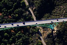 Aerial view: Western end of bridge. Cold Spring Tavern is on Stagecoach Rd. beneath the bridge, just off the top of this photo.
 -
 American Society of Civil Engineers commemorative plaque: on Stagecoach Rd.


See also
References
- ^ a b Lansing Duncan (31 March 2011), A historic view of the ‘Steel Shortcut’ bridge, Santa Ynez Valley News, retrieved 4 August 2014
- ^ Caltrans Completes Suicide Barrier on Cold Spring Canyon Bridge
- Cold Spring Bridge, dot.ca.gov, retrieved on 2007-01-31.
- List of Awards "Highways and Roads" (CA DOT CalHwyIndex.pdf), pg. 28
- Cold Spring Canyon Arch Bridge at Structurae
- "Fatal Attraction - Cold Spring Toll Hits 47", EdHat.com, November 28, 2008