Colonia Palma
Appearance
Palma, Uruguay | |
|---|---|
Village | |
 | |
| Coordinates: 30°35′3″S 57°40′45″W / 30.58417°S 57.67917°W | |
| Country | |
| Department | Artigas Department |
| Population (2011) | |
| • Total | 440 |
| Time zone | UTC -3 |
| Postal code | 55100 |
| Dial plan | +598 4778 (+4 digits) |
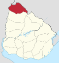
Colonia Palma is a village in the Artigas Department of northern Uruguay.
Location
It is located on Route 3, about 83 kilometres (52 mi) south of Bella Unión.
History
On 13 September 2006, its status was elevated to "Pueblo" (village) by the Act of Ley Nº 18.014.[1]
Population
In 2011 Colonia Palma had a population of 440.[2]
| Year | Population |
|---|---|
| 1996 | 166 |
| 2004 | 416 |
| 2011 | 440 |
Source: Instituto Nacional de Estadística de Uruguay[3]
References
- ^ "Ley Nº 18.014". República Oriental del Uruguay, Poder Legislativo. 2006. Archived from the original on 4 March 2016. Retrieved 6 September 2012.
{{cite web}}: Unknown parameter|dead-url=ignored (|url-status=suggested) (help) - ^ "Censos 2011 Artigas (needs flash plugin)". INE. 2012. Archived from the original on 9 October 2012. Retrieved 25 August 2012.
{{cite web}}: Unknown parameter|deadurl=ignored (|url-status=suggested) (help) - ^ "Statistics of urban localities (1963–2004)" (PDF). INE. 2012. Retrieved 6 September 2012.[dead link]
External links


