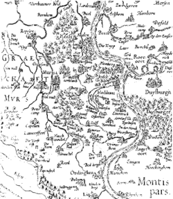
County of Moers
Appearance
County of Moers Grafschaft Moers | |
|---|---|
| before 1160–1798 | |
 Map of the County of Moers | |
| Status | State of the Holy Roman Empire |
| Capital | Moers |
| Common languages | Dutch, Cleverländisch |
| Religion | Roman-Catholic, from 1560 Protestant |
| Government | County, from 1706 Principality |
| Historical era | Middle Ages |
• Established | before 1160 |
• Disestablished | 1798 |
The County of Moers (Template:Lang-de) was a historical princely territory on the left bank of the Lower Rhine that included the towns of Moers and Krefeld as well as the surrounding villages and regions. Although the county was legally dissolved as far back as 1797/1801, the names of communal institutions and local firms often incorporate the word Grafschafter ("comital") which harks back to the County of Moers.
Footnotes
References
Literature
- Hermann Altgelt: Geschichte der Grafen und Herren von Moers. Düsseldorf, 1845.
- Karl Hirschberg: Historische Reise durch die Grafschaft Moers von der Römerzeit bis zur Jahrhundertwende, Verlag Steiger, Moers, 1975
- Gerhard Köbler: Historisches Lexikon der deutschen Länder. Die deutschen Territorien vom Mittelalter bis zur Gegenwart. Beck, Munich, 1995, ISBN 3-406-39858-8.
- Theodor Joseph Lacomblet: Urkundenbuch für die Geschichte des Niederrheins oder des Erzstifts Cöln, der Fürstenthümer Jülich und Berg, Geldern, Meurs, Cleve und Mark, und der Reichsstifte Elten, Essen und Werden. From sources in the Royal Provincial Archives of Düsseldorf and in the Church and Municipal Archives of the Province, Vol. 4, J. Wolf, 1858.
- Guido Rotthoff: Zu den frühen Generationen der Herren und Grafen von Moers. In: Annalen des Historischen Vereins für den Niederrhein. (AnnHVNdrh) 200, 1997, pp. 9–22.
- Margret Wensky: Moers Die Geschichte der Stadt von der Frühzeit bis zur Gegenwart. In: Von der preußischen Zeit bis zur Gegenwart. 2. Band, 2000, Böhlau Verlag, Cologne, Weimar, Vienna. ISBN 3-412-04600-0.
External links
Wikimedia Commons has media related to County of Moers.
- Moers town history, short table
- Moers Municipal Archives
- nbn-resolving.de Digitalised edition of the History of the County of Moers (Geschichte der Grafschaft Moers) by Carl Hirschberg
- Comital Museum (Grafschafter Museum)


