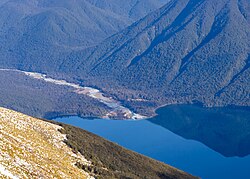
D'Urville River
Appearance
| D'Urville River | |
|---|---|
 | |
| Physical characteristics | |
| Source | |
| • location | Spenser Mountains |
| • elevation | 1,480 m (4,860 ft) |
| Mouth | |
• location | Lake Rotoroa |
• elevation | 420 m (1,380 ft) |
| Length | 26 km (16 mi) |
The D'Urville River is in the South Island of New Zealand.
It lies within the Nelson Lakes National Park and flows north for 26 kilometres (16 mi) between the Ella and Mahanga ranges into Lake Rotoroa.[1] It is one of the smaller rivers in the Buller River system. The river was named after the French navigator Jules Dumont d'Urville by Julius von Haast.[2]
Brown and rainbow trout can be fished in the D'Urville River.[3]
A tramping track runs along the river.[4]
References
- ^ Peter Dowling (editor) (2004). Reed New Zealand Atlas. Reed Books. Map 65. ISBN 0-7900-0952-8.
{{cite book}}:|author=has generic name (help); Unknown parameter|nopp=ignored (|no-pp=suggested) (help) - ^ Discover New Zealand:A Wises Guide (9th ed.). 1994. p. 294.
- ^ "D'Urville River Trout Fishing". Retrieved 29 August 2009.
- ^ "New Zealand Nelson Lakes D'Urville Valley". Retrieved 29 August 2009.
41°54′35″S 172°39′04″E / 41.90972°S 172.65111°E
