Dalnabreck
Appearance
Dalnabreck
| |
|---|---|
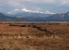
 Peat banks between Mingarry and Dalnabreck, looking west. | |
Location within the Lochaber area | |
| OS grid reference | NM701697 |
| Council area | |
| Country | Scotland |
| Sovereign state | United Kingdom |
| Post town | Acharacle |
| Postcode district | PH36 4 |
| Police | Scotland |
| Fire | Scottish |
| Ambulance | Scottish |
Dalnabreck (Scottish Gaelic: Dail nam Breac) is a small village, lying at the southwest end of Loch Shiel in Sunart, Lochaber, Scottish Highlands and is in the Scottish council area of Highland.[1]
The A861 road runs through Dalnabreck, with Acharacle 2 miles east on the A861 and Ardmolich 1 mile north east along the A861 road.
References
- ^ "Dalnabreck". The Gazetteer for Scotland. School of GeoSciences, University of Edinburgh and The Royal Scottish Geographical Society. Retrieved 17 June 2018.

