Dommel
| Dommel | |
|---|---|
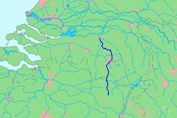
 Location map of the Dommel. | |
| Physical characteristics | |
| Source | |
| • location | Campine |
| Mouth | |
• location | Dieze |
| Length | 146 km (91 mi) |

The Dommel is a stream in Belgium and the Netherlands, left tributary of the Dieze. It rises in north-eastern Belgium near Peer and flows into the southern part of the Netherlands. The Dommel takes in water from the Keersop, Tongelreep, Run, Gender and Kleine Dommel streams and merges at 's-Hertogenbosch with the Aa stream to form river Dieze, which subsequently flows towards the Meuse. The main cities and towns along the Dommel's course are Peer, Neerpelt, Valkenswaard, Dommelen, Eindhoven, Son en Breugel, Sint-Oedenrode, Boxtel, Sint-Michielsgestel and 's-Hertogenbosch. The most original part and natural state of the Dommel can be found between Eindhoven and Boxtel. Here the Dommel has still its original winds and meanders and forms a cultural-historical and valuable landscape area called the Dommelbeemden.
External links
- Dommel Corridor Eindhoven - Photography
Gallery
-
The Dommel in Sint Michielsgestel
-
The Dommel at the Dommelbeemden in Sint-Oedenrode
- Meuse drainage basin
- International rivers of Europe
- Subterranean rivers
- Rivers of Belgium
- Rivers of the Netherlands
- Rivers of Limburg (Belgium)
- Rivers of North Brabant
- Eindhoven
- 's-Hertogenbosch
- Valkenswaard
- North Brabant geography stubs
- Europe river stubs
- Netherlands geography stubs
- Belgian Limburg geography stubs
- Belgium river stubs


