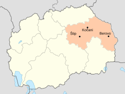
Eastern Statistical Region
Eastern Statistical Region
Источен регион | |
|---|---|
 | |
| Country | |
| Area | |
| • Total | 3,539 km2 (1,366 sq mi) |
| Population (2014) | |
| • Total | 177,411 |
| • Density | 50/km2 (130/sq mi) |
The Eastern Statistical Region (Macedonian: Источен регион) is one of eight statistical regions of the Republic of Macedonia. Eastern, located in the eastern part of the country, borders Bulgaria. Internally, it borders the Vardar, Skopje, Northeastern, and Southeastern statistical regions.
Municipalities

Eastern statistical region is divided into 11 municipalities:
 Berovo
 Češinovo-Obleševo
 Delčevo
 Karbinci
 Kočani
 Makedonska Kamenica
 Pehčevo
 Probištip
 Štip
Štip Vinica Municipality, Macedonia
 Zrnovci
Demographics

Population
The current population of the Eastern Statistical Region is 181,858 citizens or 9.0% of the total population of the Republic of Macedonia, according to the last population census in 2002.
| Census Year | Population | Change |
|---|---|---|
| 1994 | 180,039 | N/A |
| 2002 | 181,858 | +1.01% |
Ethnicities
The largest ethnic group in the region are the Macedonians.
| Number | % | |
| TOTAL | 181,858 | 100 |
| Macedonians | 168,046 | 92.4 |
| Romany | 6,876 | 3.8 |
| Turks | 2,794 | 1.5 |
| Vlachs | 2,074 | 1.1 |
| others | 2,068 | 1.1 |
Wikimedia Commons has media related to Eastern Statistical Region.
Wikivoyage has a travel guide for Eastern Macedonia.
