Edmund, Wisconsin
Appearance
Edmund, Wisconsin | |
|---|---|
Census-designated place | |
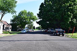
 Looking down Main Street in Edmund | |
| Coordinates: 42°58′03″N 90°15′52″W / 42.96750°N 90.26444°W | |
| Country | United States |
| State | Wisconsin |
| County | Iowa |
| Area | |
• Total | 0.342 sq mi (0.89 km2) |
| • Land | 0.342 sq mi (0.89 km2) |
| • Water | 0 sq mi (0 km2) |
| Elevation | 1,204 ft (367 m) |
| Population (2010) | |
• Total | 173 |
| • Density | 510/sq mi (200/km2) |
| Time zone | UTC-6 (Central (CST)) |
| • Summer (DST) | UTC-5 (CDT) |
| Area code | 608 |
| GNIS feature ID | 1564455[1] |
Edmund is an unincorporated census-designated place located in the town of Linden in Iowa County, Wisconsin, United States. Edmund is located on U.S. Route 18 west of Dodgeville. The community's post office closed on November 2, 2002.[2] As of the 2010 census, Edmund's population was 173.[3]
History
Edmund got its name in 1881 from Edmund V. Baker who owned the land where the settlement was located.[4]
References
- ^ U.S. Geological Survey Geographic Names Information System: Edmund, Wisconsin
- ^ "Postmaster Finder - Post Offices by ZIP Code". United States Postal Service. Retrieved September 25, 2011.
- ^ "American FactFinder". U.S. Census Bureau. Retrieved 3 April 2011.
- ^ Chicago and North Western Railway Company (1908). A History of the Origin of the Place Names Connected with the Chicago & North Western and Chicago, St. Paul, Minneapolis & Omaha Railways. p. 67.


