El Carmen District, Chincha
Appearance
El Carmen | |
|---|---|
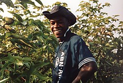
 A person collecting cotton at El Carmen | |
 | |
| Country | |
| Region | Ica |
| Province | Chincha |
| Founded | August 28, 1916 |
| Capital | El Carmen |
| Government | |
| • Mayor | José Alberto Soria Calderon |
| Area | |
• Total | 790.82 km2 (305.34 sq mi) |
| Elevation | 155 m (509 ft) |
| Population | |
• Total | 12,777 |
| • Density | 16/km2 (42/sq mi) |
| Time zone | UTC-5 (PET) |
| UBIGEO | 110205 |
| Website | www.munielcarmen.gob.pe/ |
El Carmen District is one of eleven districts of the province Chincha in Peru.[1]
Gallery
[edit]-
Nuestra Señora Del Carmen
See also
[edit]References
[edit]- ^ (in Spanish) Instituto Nacional de Estadística e Informática. Banco de Información Distrital Archived April 23, 2008, at the Wayback Machine. Retrieved April 11, 2008.

