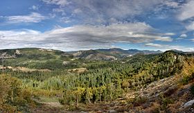
Emigrant Gap
| Emigrant Gap | |
|---|---|
 | |
| Elevation | ~5,200 ft. / 1,585 m |
| Traversed by | |
| Location | Placer County, California, United States |
| Range | Sierra Nevada |
| Coordinates | 39°18′11″N 120°39′58″W / 39.303°N 120.666°W |
| Reference no. | 403 |
Emigrant Gap is a gap in a ridge on the California Trail as it crosses the Sierra Nevada, to the west of what is now known as Donner Pass. Here the cliffs are so steep that, back in the 1840s, the pioneers on their way to California had to lower their wagons on ropes in order to continue.
The Emigrant Gap was so named because it was a low gap on a ridge where the emigrants' wagons crossed from the American River drainage to the Bear River drainage. It was part of the Truckee Route, a portion of the California Trail by which pioneers, heading west, emigrated from the United States to California, which was part of Mexico until it was captured by the United States in the Mexican–American War (1846–1848).
There is a California historical marker (number 403), dedicated on June 25, 1950, on Interstate 80 commemorating this brave and arduous task.
- The spring of 1845 saw the first covered wagons surmount the Sierra Nevada Mountains. They left this valley, ascended to the ridge, and turned westward to old Emigrant Gap. The wagons were lowered by ropes to the floor of Bear Valley. Hundreds followed before, during, and after the gold rush. This was a hazardous portion of the overland emigrant trail.[1]
The small unincorporated community of Emigrant Gap is adjacent to the gap.
The Stephens–Townsend–Murphy Party were the first to cross Emigrant Gap and the Sierra, doing so in 1844–45.

Climate
[edit]Blue Canyon–Nyack Airport has a warm-summer Mediterranean climate (Csb) according to the Köppen climate classification system. Summers are generally warm with cool nights, while winters are cold and extremely snowy.
| Climate data for Emigrant Gap, California (Lake Spaulding), 1981-2010 temperature and precipitation normals, snowfall and extremes 1902–2003 | |||||||||||||
|---|---|---|---|---|---|---|---|---|---|---|---|---|---|
| Month | Jan | Feb | Mar | Apr | May | Jun | Jul | Aug | Sep | Oct | Nov | Dec | Year |
| Record high °F (°C) | 72 (22) |
80 (27) |
78 (26) |
85 (29) |
96 (36) |
96 (36) |
102 (39) |
104 (40) |
97 (36) |
94 (34) |
79 (26) |
75 (24) |
104 (40) |
| Mean maximum °F (°C) | 60.2 (15.7) |
62.3 (16.8) |
65.7 (18.7) |
71.9 (22.2) |
79.5 (26.4) |
86.7 (30.4) |
90.4 (32.4) |
89.5 (31.9) |
86.4 (30.2) |
79.4 (26.3) |
69.1 (20.6) |
61.9 (16.6) |
90.8 (32.7) |
| Mean daily maximum °F (°C) | 45.1 (7.3) |
47.0 (8.3) |
51.0 (10.6) |
57.2 (14.0) |
65.3 (18.5) |
74.7 (23.7) |
81.6 (27.6) |
81.5 (27.5) |
75.4 (24.1) |
64.9 (18.3) |
49.2 (9.6) |
44.0 (6.7) |
61.4 (16.3) |
| Daily mean °F (°C) | 34.4 (1.3) |
36.2 (2.3) |
38.5 (3.6) |
43.4 (6.3) |
50.2 (10.1) |
57.8 (14.3) |
64.0 (17.8) |
62.9 (17.2) |
58.5 (14.7) |
50.5 (10.3) |
41.2 (5.1) |
35.8 (2.1) |
47.6 (8.7) |
| Mean daily minimum °F (°C) | 24.3 (−4.3) |
25.1 (−3.8) |
27.2 (−2.7) |
30.3 (−0.9) |
36.1 (2.3) |
42.3 (5.7) |
46.3 (7.9) |
45.9 (7.7) |
42.2 (5.7) |
35.9 (2.2) |
28.1 (−2.2) |
24.6 (−4.1) |
34.0 (1.1) |
| Mean minimum °F (°C) | 8.1 (−13.3) |
10.5 (−11.9) |
12.8 (−10.7) |
18.4 (−7.6) |
25.7 (−3.5) |
31.6 (−0.2) |
37.6 (3.1) |
36.5 (2.5) |
32.0 (0.0) |
25.7 (−3.5) |
17.1 (−8.3) |
10.3 (−12.1) |
4.1 (−15.5) |
| Record low °F (°C) | −5 (−21) |
−8 (−22) |
−2 (−19) |
6 (−14) |
13 (−11) |
24 (−4) |
31 (−1) |
30 (−1) |
23 (−5) |
13 (−11) |
4 (−16) |
−14 (−26) |
−14 (−26) |
| Average precipitation inches (mm) | 12.63 (321) |
13.86 (352) |
10.95 (278) |
6.20 (157) |
3.76 (96) |
1.38 (35) |
0.28 (7.1) |
0.31 (7.9) |
1.63 (41) |
3.77 (96) |
10.77 (274) |
13.10 (333) |
78.64 (1,998) |
| Average snowfall inches (cm) | 53.8 (137) |
49.0 (124) |
49.1 (125) |
23.5 (60) |
6.4 (16) |
0.5 (1.3) |
0.0 (0.0) |
0.0 (0.0) |
0.1 (0.25) |
2.5 (6.4) |
17.9 (45) |
40.5 (103) |
243.3 (617.95) |
| Average precipitation days (≥ 0.01 in) | 12 | 12 | 12 | 9 | 7 | 4 | 1 | 1 | 3 | 5 | 9 | 11 | 86 |
| Source: WRCC (temperature and precipitation averages 1981–2010, other values 1902-2003)
"Lake Spaulding, CA (044713./)". Western Regional Climate Center. Retrieved November 29, 2015. </ref> | |||||||||||||
References
[edit]- ^ http://ceres.ca.gov/geo_area/counties/Placer/landmarks.html Archived 2005-04-16 at the Wayback Machine ceres.ca.gov
- Stewart, George R. (1983). The California Trail: An Epic with Many Heroes. University of Nebraska Press. p. 339. ISBN 0-8032-9143-4.
- "Recreational Activities: More Information About Big Bend". Tahoe National Forest. Retrieved 2008-05-11.
- Krizek, John (producer). Forgotten Journey: The Stephens-Townsend-Murphy Saga. Archived from the original on 2007-09-27. Retrieved 2008-05-11.
External links
[edit] Media related to Emigrant Gap at Wikimedia Commons
