
Erie Harbor North Pier Light
 | |
 | |
| Location | Presque Isle State Park, Pennsylvania, United States |
|---|---|
| Coordinates | 42°09′24.12″N 80°04′14.16″W / 42.1567000°N 80.0706000°W |
| Tower | |
| Constructed | 1858 |
| Foundation | Pier[1] |
| Construction | Wrought iron encased in steel |
| Automated | Yes |
| Height | 34 feet (10 m) |
| Shape | Square pyramidal |
| Markings | White with black horizontal band |
| Operator | United States Coast Guard |
| Light | |
| Focal height | 13 m (43 ft) |
| Lens | Fourth order Fresnel |
| Range | 6 nmi (11 km; 6.9 mi) |
| Characteristic | Red, Flashing |
The Erie Harbor North Pier Light, also known as the Presque Isle North Pier Light, is one of the three lighthouses near Erie, Pennsylvania in the United States. The light, situated at the far eastern end of Presque Isle State Park, helps mariners as they traverse the narrow inlet between Lake Erie and Presque Isle Bay.
Originally constructed as a wooden tower in 1830, that light was swept away by a schooner in 1857.[2] The current structure was forged in France and assembled on site in Erie. It was moved in 1882 and again in 1940. The United States Coast Guard, which operates the beacon, changed its fixed red beam to an automated red flashing light in 1995, at which time the 4th order Fresnel lens was sent to the Erie Maritime Museum.
-
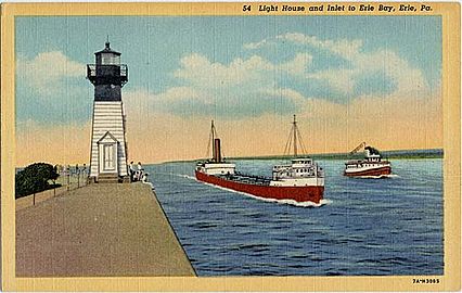 Light on a pre-1930 postcard

References
- ^ "Erie Harbor North Pierhead Light". National Park Service. December 6, 2002. Retrieved 2007-05-24.
- ^ Bates, Samuel P (1884). History of Erie County. Chicago: Warner, Beers & Co.
Further reading
- Oleszewski, Wes (1998). Great Lakes Lighthouses, American and Canadian: A Comprehensive Directory / Guide to Great Lakes Lighthouses. Gwinn, MI: Avery Color Studios. ISBN 0-932212-98-0.
- United States Coast Guard (1957). Historically Famous Lighthouses. Washington, DC: Government Printing Office.
- Wright, Larry; Patricia Wright (2006). Great Lakes Lighthouses Encyclopedia. Erin, ON: Boston Mills Press. ISBN 1-55046-399-3.
