Eslohe

From Wikipedia, the free encyclopedia

This is an old revision of this page, as edited by Färber (talk | contribs) at 06:09, 9 June 2015. The present address (URL) is a permanent link to this revision, which may differ significantly from the current revision.

Eslohe
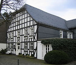
Timbered house in Eslohe
Coat of arms of Eslohe
Location of Eslohe within Hochsauerlandkreis district
HesseSiegen-WittgensteinHöxter (district)Olpe (district)Paderborn (district)Soest (district)Märkischer KreisOlsbergMeschedeWinterbergMarsbergBestwigEsloheSundernHallenbergMedebachBrilonSchmallenbergArnsbergNorth Rhine-Westphalia
CountryGermany
StateNorth Rhine-Westphalia
Admin. regionArnsberg
DistrictHochsauerlandkreis
Subdivisions4
Government
 • MayorStephan Kersting (CDU)
Area
 • Total113.37 km2 (43.77 sq mi)
Elevation
404 m (1,325 ft)
Population
 (2022-12-31)[1]
 • Total8,920
 • Density79/km2 (200/sq mi)
Time zoneUTC+01:00 (CET)
 • Summer (DST)UTC+02:00 (CEST)
Postal codes
59889
Dialling codes02973
Vehicle registrationHSK
Websitewww.eslohe.de
Eslohe

Eslohe is a municipality in the Hochsauerland district, in North Rhine-Westphalia, Germany.

Geography

Eslohe is situated approximately 25 km south-west of Meschede.

Neighbouring municipalities

Division of the town

After the local government reforms of 1975 Eslohe consists of the following districts:

  • Beisinghausen
  • Bockheim
  • Bremke
  • Bremscheid
  • Büemke
  • Büenfeld
  • Cobbenrode
  • Dormecke
  • Einberg
  • Eslohe
  • Fredebeil
  • Friedrichstal
  • Frielinghausen
  • Glamke
  • Haus Blessenohl
  • Haus Wenne
  • Hengsbeck
  • Hengslade
  • Henninghausen
  • Herhagen
  • Herscheid
  • Husen
  • In der Marpe
  • Isingheim
  • Kückelheim
  • Landenbeck
  • Larmecke
  • Leckmart
  • Lochtrop
  • Lohof
  • Lüdingheim
  • Nichtinghausen
  • Nieder-Landenbeck
  • Niedermarpe
  • Niedersalwey
  • Ober-Landenbeck
  • Obermarpe
  • Obersalwey
  • Oesterberge
  • Reiste
  • Sallinghausen
  • Schwartmecke
  • Sieperting
  • Stertberg
  • Wenholthausen
  • Wilhelmshöhe

Twin Towns

References

  1. ^ "Bevölkerung der Gemeinden Nordrhein-Westfalens am 31. Dezember 2022 – Fortschreibung des Bevölkerungsstandes auf Basis des Zensus vom 9. Mai 2011" (in German). Landesbetrieb Information und Technik NRW. Retrieved 20 June 2023.

External links