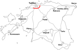
Estonian national road 11
| National Road 11 | ||||
|---|---|---|---|---|
| Põhimaantee 11 | ||||
 | ||||
| Route information | ||||
| Length | 38 km (24 mi) | |||
| Major junctions | ||||
| From | Nehatu | |||
| To | Keila | |||
| Location | ||||
| Country | Estonia | |||
| Major cities | Tallinn, Saue, Keila | |||
| Highway system | ||||
| ||||
Põhimaantee 11 (ofcl. abbr. T11; Tallinn ring road) is a semi-orbital highway around the city of Tallinn. The highway starts in Nehatu, Tallinn. From there the main cities passed are Jüri, Saku and Saue. The highway ends in Keila, when intersecting with the T8.
The road serves a connection between Tallinn's metropolitan area and the numerous national routes that intersect it. In 2015, the highest traffic volumes were between Nehatu and Luige, with an AADT of 12 500. The rest of the route had a stable AADT of around 9 000.[1]
The road is a dual carriageway (I class highway) for 9,6 kilometres. The only section is found between Luige and Jüri. Currently there are ongoing construction works at Jüri and Juuliku in order to widen the road. By 2020, the route is planned to be entirely dual carriageway between Nehatu and Saue (29 kilometres).
Route
The T11 (Estonian: Põhimaantee 11; Tallinna ringtee) is a semi-orbital highway around Tallinn, connecting it's metropolitan region to numerous national main routes. The road also serves as a compulsory truck traffic route (as in Nõmme, the T4 is banned for truck traffic). The T11 is a part of the European route E265.[2]
The highway begins in Nehatu from the intersection with the T1 and Rahu tee. The road then starts to orbit Tallinn, heading southwest. At Jüri, the road intersects with the T2 at a roundabout interchange and turns west. After the interchange, the road turns into a 2+2 I class highway, and stays like that for 9,6 kilometres. During this stretch, the road intersects with the T115 and T15 (at Kurna and Luige, respectively). After the Luige interchange, the road turns into a 1+1 again. At Saue, the road intersects with the T4 on a cloverleaf. After Saue the road continues westbound and terminates at a roundabout with the T8 outside Keila.
Currently there are no speed cameras on the T11.[3]


