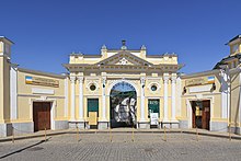
Eupatorian Kenassas
Appearance
| Eupatorian Kenassas | |
|---|---|
 Entrance to the Karaite Kenassa in Yevpatoria | |
| Religion | |
| Affiliation | Karaite |
| Status | Active |
| Location | |
| Location | Yevpatoria |
| State | |
| Territory | |
| Geographic coordinates | 45°11′55″N 33°22′27″E / 45.19861°N 33.37417°E |
| Architecture | |
| Type | Kenesa |
| Completed | 1837 |
The Eupatorian Kenassas is the temple complex of Crimean Karaites (karaev) located in Eupatoria, Crimea. It covers an area of 0.25 hectares and consists of large and small kenesa buildings (meetinghouses), building religious schools (Midrash), charity dining, household courtyards and multiple courtyards (grape, marble, waiting for the prayer Ritual, Memorial). The kenesa has been a centre of the religious life of the Karaites of Yevpatoria since 1837.
