Faetano
Appearance
FaetanNo | |
|---|---|
castello | |
 Church of San Paolo Apostolo and the town hall (Casa del Castello) in Faetano | |
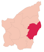
 Faetano's location in San Marino | |
| Country | |
| Government | |
| • Capitano | Pier Mario Bedetti (since 2003) |
| Area | |
| • Total | 7.75 km2 (2.99 sq mi) |
| Elevation | 362 m (1,188 ft) |
| Population (31 October 2013) | |
| • Total | 1,164 |
| Time zone | UTC+1 (CET) |
| • Summer (DST) | CEST |
| Postal code | 47896 |
Faetano is one of the 9 communes or "castelli" of San Marino. It has 1,164 inhabitants (October 2013) in an area of 7,75 km².
Geography
It borders on the San Marino municipalities Montegiardino, Fiorentino, Borgo Maggiore, and Domagnano and the Italian municipalities Coriano, Montescudo and Sassofeltrio.
History
It was attached voluntarily to San Marino in 1463 in the last territorial expansion.
Parishes
Faetano has four parishes (curazie):
External links
![]() Media related to Faetano at Wikimedia Commons
Media related to Faetano at Wikimedia Commons
Template:San Marino 43°55′32″N 12°29′54″E / 43.92556°N 12.49833°E


