Fall Creek Falls
Appearance
For other sites called Falling Creek Falls see Falling Creek Falls (disambiguation)
| Fall Creek Falls | |
|---|---|
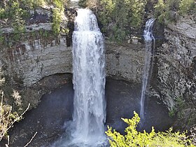
 Fall Creek Falls on the left, Coon Creek Falls on the right | |
 | |
| Location | Spencer, Tennessee, United States |
| Coordinates | 35°39′59″N 85°21′24″W / 35.66642°N 85.35655°W |
| Type | Plunge |
| Total height | 256 feet (78 m) |
| Watercourse | Fall Creek |
Fall Creek Falls is the highest free-fall waterfall east of the Mississippi River. The falls are located near Spencer, Tennessee in Fall Creek Falls State Park. A short trail leads from the parking lot atop the plateau down to the base of the gorge, giving access to the waterfall's plungepool. When water flow is sufficient, Coon Creek Falls shares a plungepool.
