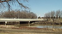
Fargo-Moorhead Toll Bridge
Appearance
Fargo-Moorhead Toll Bridge | |
|---|---|
 | |
| Coordinates | 46°53′23″N 96°46′28″W / 46.88972°N 96.77444°W |
| Carries | 2 lanes of |
| Crosses | Red River |
| Locale | Fargo, North Dakota Moorhead, Minnesota |
| History | |
| Opened | 1988 |
| Statistics | |
| Toll | $0.75 |
| Location | |
 | |
The Fargo-Moorhead Toll Bridge is a toll bridge located on the Red River of the North between Fargo, North Dakota and Moorhead, Minnesota. It connects Moorhead's 15th Avenue N with Fargo's 12th Avenue N. The bridge is a terminus for the unsigned North Dakota Highway 294 (ND 294).
The toll is $0.75; pedestrian traffic on the sidewalk is not tolled.[1] The bridge was to be privately operated until June 1, 2018, following a five-year extension of its original 25-year charter in 2013.[2][3]
In May 2014, The City of Moorhead sued Bridge Co., the owners of the bridge; and the city of Fargo. Judge Frank Racek ruled in favor of the city of Moorhead and that the ownership of the bridge would be transferred to the two cities.[4]
See also
References
- ^ "Wikimapia - Let's describe the whole world!". wikimapia.org.
- ^ http://www.valleynewslive.com/story/21676374/fargo-weighs-in-on-toll-bridge-debate
- ^ Alison Voorhees. "KVRR Fox Fargo Moorhead - North Broadway Toll Bridge Closed". kvrr.com.
- ^ "Judge's ruling gives northside toll bridge to Fargo, Moorhead". WDAY.
