
File:AKP-Aerial Map.jpg
No higher resolution available.
AKP-Aerial_Map.jpg (576 × 384 pixels, file size: 149 KB, MIME type: image/jpeg)
| This is a file from the Wikimedia Commons. Information from its description page there is shown below. Commons is a freely licensed media file repository. You can help. |
Summary
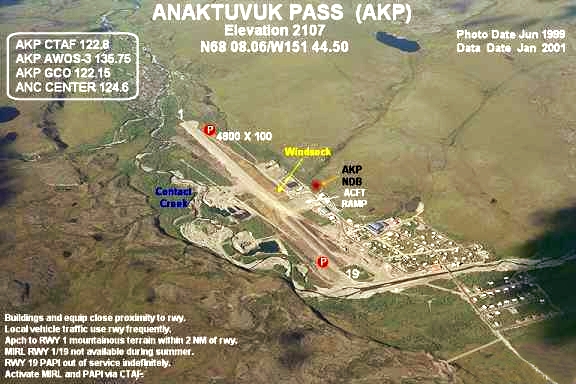
| Description | Annotated aerial photograph of Anaktuvuk Pass Airport (FAA: AKP) in Anaktuvuk Pass, Alaska, United States. |
| Date |
Photo: June 1998 Data: January 2001 |
| Source |
Image: http://www.alaska.faa.gov/fai/images/NSLPBR/AKP-c.jpg Web site: Alaska Airport Photos and Diagrams. Archived from the original on 2007-11-14. Retrieved on 2008-03-05. |
| Author | Federal Aviation Administration, Alaskan Region |
| Permission (Reusing this file) |
Public domain |
| Object location | | View this and other nearby images on: OpenStreetMap |
|---|
Licensing
This image or file is a work of a Federal Aviation Administration employee, taken or made as part of that person's official duties. As a work of the U.S. federal government, the image is in the public domain in the United States.
|
 |
Original upload log
The original description page was here. All following user names refer to en.wikipedia.
- 2007-07-04 05:05 Zyxw 576×384×8 (27329 bytes) Photograph of [[Anaktuvuk Pass Airport]] (AKP) in [[Anaktuvuk Pass, Alaska]], United States. http://www.alaska.faa.gov/fai/airports.htm http://www.alaska.faa.gov/fai/images/NSLPBR/AKP-c.jpg
File history
Click on a date/time to view the file as it appeared at that time.
| Date/Time | Thumbnail | Dimensions | User | Comment | |
|---|---|---|---|---|---|
| current | 11:29, 15 December 2011 | | 576 × 384 (149 KB) | Hic et nunc | removed watermark, contrast, colour |
| 02:33, 5 March 2008 |  | 576 × 384 (27 KB) | John Bot II | {{Information |Description={{en|Photograph of en:Anaktuvuk Pass Airport (AKP) in en:Anaktuvuk Pass, Alaska, United States. http://www.alaska.faa.gov/fai/airports.htm http://www.alaska.faa.gov/fai/images/NSLPBR/AKP-c.jpg [[:en:Category:FAA |
File usage
The following pages on the English Wikipedia use this file (pages on other projects are not listed):
Global file usage
The following other wikis use this file:
- Usage on arz.wikipedia.org
- Usage on ceb.wikipedia.org
- Usage on de.wikipedia.org
- Usage on es.wikipedia.org
- Usage on fa.wikipedia.org
- Usage on ru.wikipedia.org
- Usage on tg.wikipedia.org
- Usage on www.wikidata.org