
File:Africa proconsularis SPQR.png

Size of this preview: 800 × 548 pixels. Other resolutions: 320 × 219 pixels | 640 × 438 pixels | 1,024 × 701 pixels | 1,280 × 877 pixels | 1,600 × 1,096 pixels.
Original file (1,600 × 1,096 pixels, file size: 42 KB, MIME type: image/png)
| This is a file from the Wikimedia Commons. Information from its description page there is shown below. Commons is a freely licensed media file repository. You can help. |
Summary
Basis · Grundlage · bazo: image:Romia Imperio.png + image:Romia Imperio sen provinconomoj.png (the second image without names of provinces)
Adaptation · Bearbeitung · prilaboro: ThomasPusch (june 2007)

|
Permission is granted to copy, distribute and/or modify this document under the terms of the GNU Free Documentation License, Version 1.2 or any later version published by the Free Software Foundation; with no Invariant Sections, no Front-Cover Texts, and no Back-Cover Texts. A copy of the license is included in the section entitled GNU Free Documentation License. |
| This file is licensed under the Creative Commons Attribution-Share Alike 3.0 Unported license. | ||
| ||
| This licensing tag was added to this file as part of the GFDL licensing update. |
File history
Click on a date/time to view the file as it appeared at that time.
| Date/Time | Thumbnail | Dimensions | User | Comment | |
|---|---|---|---|---|---|
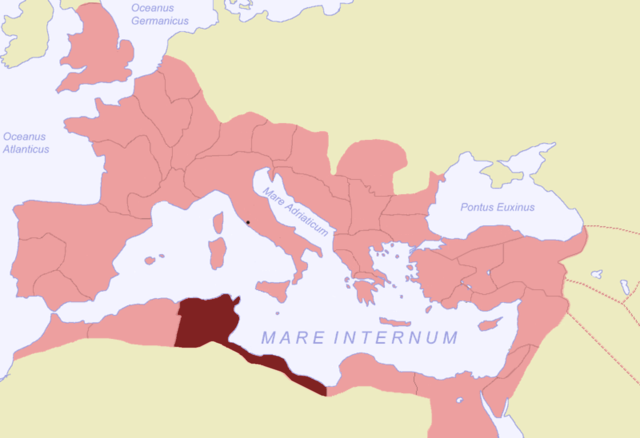
| current | 04:31, 27 June 2007 | | 1,600 × 1,096 (42 KB) | ThomasPusch | == {{int:filedesc}} == {{en|Map of the Roman Empire during 116, the province Africa proconsularis highlighted.}} {{de|Karte des Römischen Reichs von 116, d |
File usage
The following 11 pages use this file:
Global file usage
The following other wikis use this file:
- Usage on als.wikipedia.org
- Usage on ar.wikipedia.org
- Usage on br.wikipedia.org
- Usage on ca.wikipedia.org
- Usage on cy.wikipedia.org
- Usage on de.wikipedia.org
- Usage on eo.wikipedia.org
- Usage on eu.wikipedia.org
- Usage on fr.wikipedia.org
- Usage on fr.wiktionary.org
- Usage on gl.wikipedia.org
- Usage on hr.wikipedia.org
- Usage on hsb.wikipedia.org
- Usage on hu.wikipedia.org
- Usage on ia.wikipedia.org
- Usage on id.wikipedia.org
- Usage on it.wikipedia.org
- Usage on nl.wikipedia.org
- Usage on oc.wikipedia.org
- Usage on pl.wikipedia.org
- Usage on ru.wikipedia.org
- Епархия Тибики
- Епархия Руспы
- Епархия Фурноса Малого
- Епархия Тимиды
- Епархия Иунки Бизаценской
- Епархия Семты
- Епархия Каркабии
- Епархия Абари
- Епархия Акве-Альбы Бизаценской
- Епархия Абарадиры
- Епархия Аббир-Германицианы
- Епархия Аббира Великого
- Епархия Абидды
- Епархия Аборы
- Епархия Абсасаллы
- Епархия Абитины
- Епархия Аггара
- Епархия Суаса
- Епархия Аусафы
- Епархия Тибиуки
- Епархия Сегермы
- Епархия Замы Малой
- Епархия Октабы
- Епархия Оббы
View more global usage of this file.