
File:April 19, 2023 Tornado Paths surveyed by NWS Norman (Update April 21, 2023).png

Size of this preview: 800 × 523 pixels. Other resolutions: 320 × 209 pixels | 640 × 419 pixels | 1,024 × 670 pixels | 1,280 × 837 pixels | 1,783 × 1,166 pixels.
Original file (1,783 × 1,166 pixels, file size: 2.35 MB, MIME type: image/png)
| This is a file from the Wikimedia Commons. Information from its description page there is shown below. Commons is a freely licensed media file repository. You can help. |
.png)
Summary
| Description |
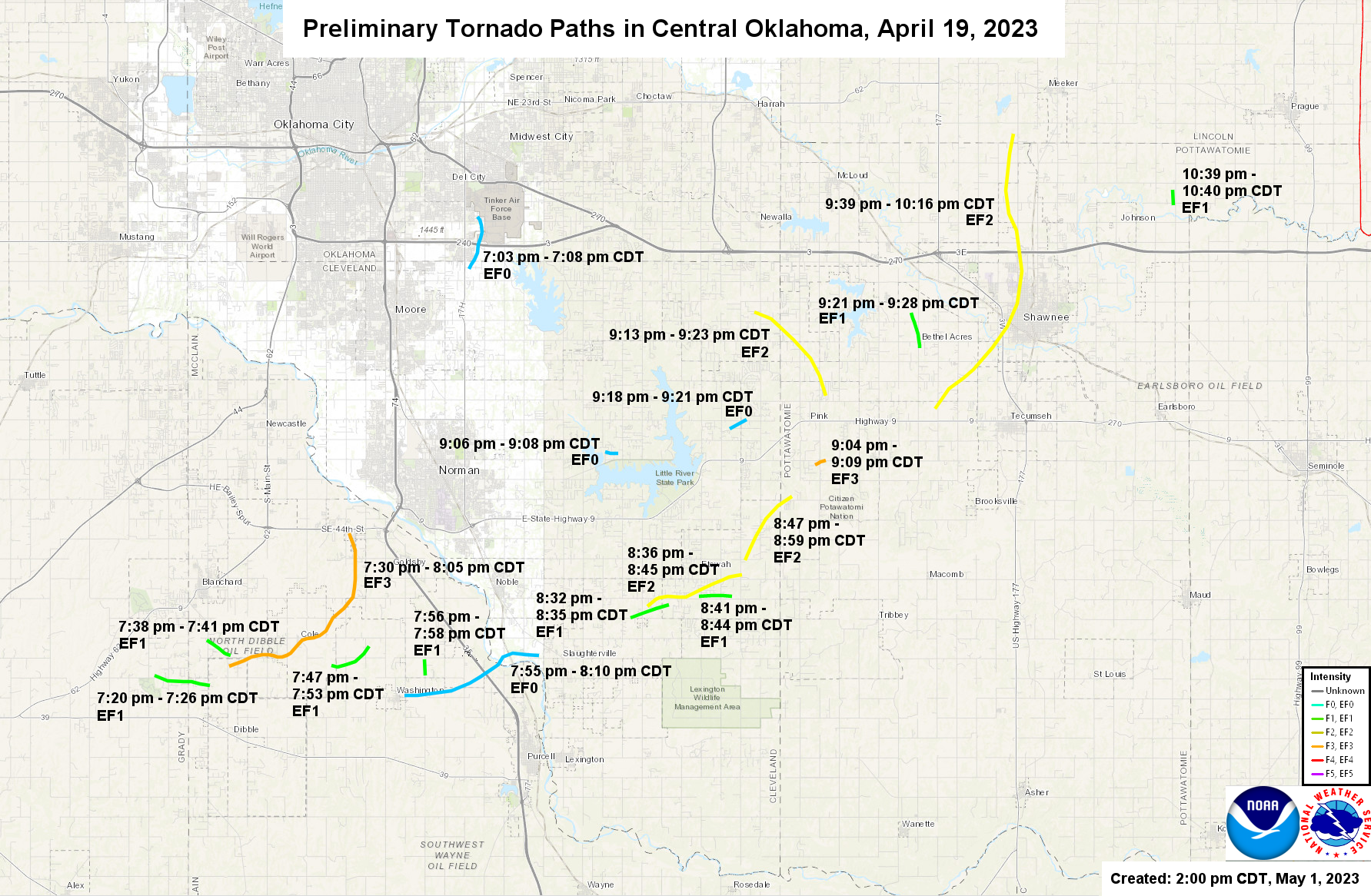
English: The tornadoes surveyed by the National Weather Service of Norman, Oklahoma for April 19, 2023. This map was updated at 4:30 PM CDT on April 21, 2023. |
| Date | |
| Source | https://www.weather.gov/oun/events-20230419 (Exact URL & Archived URL) |
| Author | National Weather Service |
Licensing
| This file is in the public domain in the United States because it was solely created by the National Weather Service (including its name from 1870–1970, the United States Weather Bureau).
As a file created by an employee of the NWS (formerly USWB) in the course of their official duties, whether hosted
this work is in the public domain in the United States because it is a work prepared by an officer or employee of the United States Government as part of that person’s official duties under the terms of Title 17, Chapter 1, Section 105 of the US Code. |
||
 |
Warnings:
|
File history
Click on a date/time to view the file as it appeared at that time.
| Date/Time | Thumbnail | Dimensions | User | Comment | |
|---|---|---|---|---|---|
| current | 19:50, 4 June 2023 | | 1,783 × 1,166 (2.35 MB) | Cyclonebiskit | May 1 update |
| 21:57, 21 April 2023 |  | 1,454 × 938 (1.59 MB) | WeatherWriter | Uploaded a work by National Weather Service from https://www.weather.gov/oun/events-20230419 ([https://www.weather.gov/images/oun/wxevents/20230419/maps/20230419-tornadopaths.png Exact URL] & [https://web.archive.org/web/20230421215343/https://www.weather.gov/images/oun/wxevents/20230419/maps/20230419-tornadopaths.png Archived URL]) with UploadWizard |
File usage
The following pages on the English Wikipedia use this file (pages on other projects are not listed):
.png)