
File:Außerfernbahn.png

Size of this preview: 800 × 503 pixels. Other resolutions: 320 × 201 pixels | 640 × 403 pixels | 1,024 × 644 pixels | 1,280 × 805 pixels | 2,560 × 1,611 pixels | 4,135 × 2,602 pixels.
Original file (4,135 × 2,602 pixels, file size: 3.51 MB, MIME type: image/png)
| This is a file from the Wikimedia Commons. Information from its description page there is shown below. Commons is a freely licensed media file repository. You can help. |
Summary
| Description |
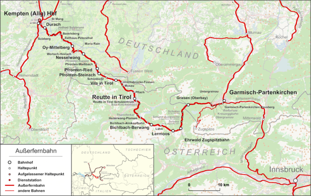
English: Map of the Ausserfern Railway in Bavaria, Germany and Tirol, Austria
Deutsch: Karte der Außerfernbahn in Bayern, Deutschland und Tirol, Österreich |
| Date | |
| Source |
Own work Map was created using:
|
| Author | |
| Permission (Reusing this file) |
Map data (c) OpenStreetMap (and) contributors, CC-BY-SA |
Licensing
This file is licensed under the Creative Commons Attribution-Share Alike 2.0 Generic license.
- You are free:
- to share – to copy, distribute and transmit the work
- to remix – to adapt the work
- Under the following conditions:
- attribution – You must give appropriate credit, provide a link to the license, and indicate if changes were made. You may do so in any reasonable manner, but not in any way that suggests the licensor endorses you or your use.
- share alike – If you remix, transform, or build upon the material, you must distribute your contributions under the same or compatible license as the original.
File history
Click on a date/time to view the file as it appeared at that time.
| Date/Time | Thumbnail | Dimensions | User | Comment | |
|---|---|---|---|---|---|
| current | 11:23, 23 March 2014 | | 4,135 × 2,602 (3.51 MB) | Pechristener | Finetuning: Lage des Bhf Innsbruck korrigiert / alle Pkt mit weisser Füllung |
| 06:02, 19 March 2014 |  | 4,135 × 2,602 (3.51 MB) | Pechristener | zwei fehlende Stationen nachgetragen | |
| 22:35, 16 March 2014 |  | 4,135 × 2,602 (3.49 MB) | Pechristener | kleine Verbesserungen | |
| 21:49, 16 March 2014 |  | 4,135 × 2,602 (3.37 MB) | Pechristener | == {{int:filedesc}} == {{Information |Description ={{en|1=Map of the Ausserfern Railway in Bavaria, Germany and Tirol, Austria}} {{de|1=Karte der Außerfernbahn in Bayern, Deutschland und Tirol, Öst... |
File usage
The following pages on the English Wikipedia use this file (pages on other projects are not listed):
Global file usage
The following other wikis use this file:
- Usage on de.wikipedia.org
- Usage on en.wiktionary.org
- Usage on hu.wikipedia.org
- Usage on ja.wikipedia.org
- Usage on nl.wikipedia.org
- Usage on uk.wikipedia.org
- Usage on www.wikidata.org