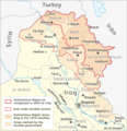
File:Autonomous Region Kurdistan-en.png
Appearance

Size of this preview: 581 × 599 pixels. Other resolutions: 233 × 240 pixels | 465 × 480 pixels | 1,012 × 1,044 pixels.
Original file (1,012 × 1,044 pixels, file size: 514 KB, MIME type: image/png)
File history
Click on a date/time to view the file as it appeared at that time.
| Date/Time | Thumbnail | Dimensions | User | Comment | |
|---|---|---|---|---|---|
| current | 11:02, 20 October 2017 |  | 1,012 × 1,044 (514 KB) | Rob984 | The southern part of the Kifri district was not incorporated. The northern part in the Sulaymaniyah Governorate was, which may be the reason for the confusions (there is effectively two "Kifri districts") |
| 17:37, 14 October 2008 |  | 1,012 × 1,044 (535 KB) | Ilyacadiz | {{Information |Description={{en|1=Map of the Autonomous Region Kurdistan, created by Maximilian Dörrbecker, translated into English by ilyacadiz }} |Source=Image:Autonome Region Kurdistan (Karte).png |Author=Maximilian Dörrbecker (Chumwa) |Date=October |
File usage
The following page uses this file:
Global file usage
The following other wikis use this file:
- Usage on af.wikipedia.org
- Usage on ca.wikipedia.org
- Usage on ckb.wikipedia.org
- Usage on fa.wikipedia.org
- Usage on fr.wikipedia.org
- Usage on he.wikipedia.org
- Usage on hr.wikipedia.org
- Usage on it.wikipedia.org
- Usage on ku.wikipedia.org
- Usage on nl.wikipedia.org
- Usage on no.wikipedia.org
- Usage on sh.wikipedia.org
- Usage on sr.wikipedia.org

