
File:Blackfriars Road Street Map 1817.jpg
No higher resolution available.
Blackfriars_Road_Street_Map_1817.jpg (372 × 304 pixels, file size: 64 KB, MIME type: image/jpeg)
| This is a file from the Wikimedia Commons. Information from its description page there is shown below. Commons is a freely licensed media file repository. You can help. |
| Description |
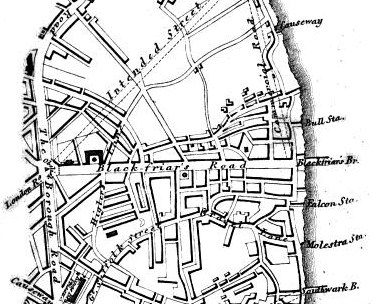
English: Cropped map from p. 330 of David Hughson, Walks through London vol. 2 (1817), showing an area on London south of the Thames. West is approximately at the top of the map, which shows an area around the southern end of Blackfriars Bridge. |
| Date | |
| Source | https://books.google.co.uk/books?id=AxAHAAAAQAAJ&pg=PA330 |
| Author | Unknown author |
|
This work is in the public domain in its country of origin and other countries and areas where the copyright term is the author's life plus 70 years or fewer. | |
| This file has been identified as being free of known restrictions under copyright law, including all related and neighboring rights. | |
File history
Click on a date/time to view the file as it appeared at that time.
| Date/Time | Thumbnail | Dimensions | User | Comment | |
|---|---|---|---|---|---|
| current | 19:31, 16 January 2012 | | 372 × 304 (64 KB) | Charles Matthews | {{Information |Description ={{en|1=Cropped map from p. 330 of David Hughson, ''Walks through London'' vol. 2 (1817), showing an area on London south of the Thames. West is approximately at the top of the map, which shows an area around the southern end |
File usage
The following page uses this file: