Jump to content

File:COVID-19 Outbreak Cases in France.svg

Page contents not supported in other languages.
This is a file from the Wikimedia Commons
From Wikipedia, the free encyclopedia

Original file (SVG file, nominally 507 × 553 pixels, file size: 188 KB)

Summary

Description
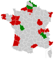
English (en): Map of the 2019-nCoV outbreak in France as of 29 February 2020. Be aware that since this is a rapidly evolving situation, new cases may not be immediately represented visually. Refer to the primary article 2019–20 outbreak of novel coronavirus 2019-nCoV or the World Health Organization's situation reports for most recent reported case information.
 
Confirmed cases reported

  • Bordeaux
  • Paris
  • Les Contamines-Montjoie
  • Montpellier
  • Oise
  • Brest
  • Mont de Marsan
  • Nice
  • Lyon
  • Dijon
  • Strasbourg
  • Angers
  • Nantes
  • Morbihan
  • Hénin-Beaumont
  • Rhône
  • Eure
  • Gard
  • Marseille
  • Mulhouse

 
Suspected cases reported

 
Hospitalizations reported

  • Lille
  • Grenoble
  • Amiens
  • Poitiers
  • Belfort

Date
Source Own work, data from Business Insider, France24 and Le Figaro
Author Night Lantern
SVG development
InfoField
 
The SVG code is valid.
 
This map was created with Inkscape.

Licensing

I, the copyright holder of this work, hereby publish it under the following license:
w:en:Creative Commons
attribution share alike
This file is licensed under the Creative Commons Attribution-Share Alike 4.0 International license.
You are free:
  • to share – to copy, distribute and transmit the work
  • to remix – to adapt the work
Under the following conditions:
  • attribution – You must give appropriate credit, provide a link to the license, and indicate if changes were made. You may do so in any reasonable manner, but not in any way that suggests the licensor endorses you or your use.
  • share alike – If you remix, transform, or build upon the material, you must distribute your contributions under the same or compatible license as the original.

Captions

Add a one-line explanation of what this file represents

Items portrayed in this file

depicts

26 January 2020

image/svg+xml

807f918781dab822d198aa009e48e04dd8b4b0e4

192,608 byte

553 pixel

507 pixel

File history

Click on a date/time to view the file as it appeared at that time.

Date/TimeThumbnailDimensionsUserComment
current13:39, 4 March 2020Thumbnail for version as of 13:39, 4 March 2020507 × 553 (188 KB)LekemokUpdated
21:20, 29 February 2020Thumbnail for version as of 21:20, 29 February 2020507 × 553 (188 KB)LekemokCorrection.
21:14, 29 February 2020Thumbnail for version as of 21:14, 29 February 2020507 × 553 (188 KB)LekemokLatest updates
14:22, 29 February 2020Thumbnail for version as of 14:22, 29 February 2020507 × 553 (188 KB)LekemokHozpitalization in Poitiers
13:54, 29 February 2020Thumbnail for version as of 13:54, 29 February 2020507 × 553 (188 KB)LekemokUpdated with places of detection of infection in red and places of hospitalization in green.
09:38, 28 February 2020Thumbnail for version as of 09:38, 28 February 2020507 × 553 (188 KB)RatherousNice
22:07, 27 February 2020Thumbnail for version as of 22:07, 27 February 2020507 × 553 (188 KB)LekemokUpdated from latest information on February 27. Source France Info, Le Telegramme and https://en.wikipedia.org/wiki/2020_coronavirus_outbreak_in_France
09:50, 8 February 2020Thumbnail for version as of 09:50, 8 February 2020507 × 553 (149 KB)Night Lanternupdated
04:52, 27 January 2020Thumbnail for version as of 04:52, 27 January 2020507 × 553 (149 KB)Night LanternUser created page with UploadWizard

The following page uses this file:

Global file usage

The following other wikis use this file:

Metadata