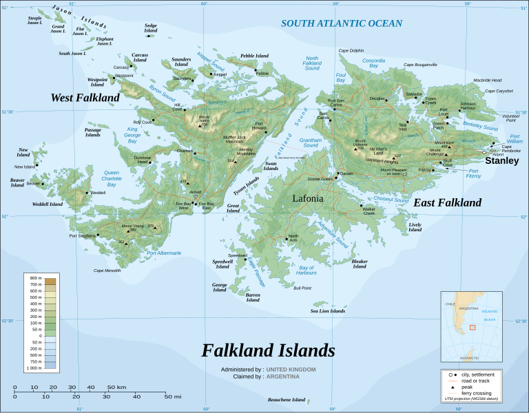
File:Falkland Islands topographic map-en.svg
Appearance

Size of this PNG preview of this SVG file: 768 × 599 pixels. Other resolutions: 308 × 240 pixels | 615 × 480 pixels | 984 × 768 pixels | 1,280 × 999 pixels | 2,560 × 1,998 pixels | 2,550 × 1,990 pixels.
Original file (SVG file, nominally 2,550 × 1,990 pixels, file size: 1.97 MB)
| This is a featured picture, which means that members of the community have identified it as one of the finest images on the English Wikipedia, adding significantly to its accompanying article. If you have a different image of similar quality, be sure to upload it using the proper free license tag, add it to a relevant article, and nominate it. |
| This image was selected as picture of the day on the English Wikipedia for August 25, 2007. |
File history
Click on a date/time to view the file as it appeared at that time.
| Date/Time | Thumbnail | Dimensions | User | Comment | |
|---|---|---|---|---|---|
| current | 02:51, 23 August 2021 |  | 2,550 × 1,990 (1.97 MB) | Praça de Maio | File uploaded using svgtranslate tool (https://svgtranslate.toolforge.org/). Added translation for tr. |
| 02:50, 23 August 2021 |  | 2,550 × 1,990 (1.97 MB) | Praça de Maio | File uploaded using svgtranslate tool (https://svgtranslate.toolforge.org/). Added translation for tr. | |
| 11:54, 6 April 2017 |  | 2,550 × 1,990 (1.91 MB) | RaviC | + New Haven Ferry | |
| 18:38, 19 December 2008 |  | 2,550 × 1,990 (1.93 MB) | Sting | Reverted to version as of 03:38, 14 November 2007: please upload the translated version under a specific name | |
| 18:26, 19 December 2008 |  | 2,550 × 1,990 (1.93 MB) | Vitek | this is just croatian translation | |
| 03:38, 14 November 2007 |  | 2,550 × 1,990 (1.93 MB) | Sting | New version more accurate and with shaded relief | |
| 01:18, 16 June 2007 |  | 2,550 × 1,990 (1.03 MB) | Sting | Reverted to earlier revision | |
| 01:03, 16 June 2007 |  | 2,550 × 1,990 (2.14 MB) | Sting | Trying to fix the bug on WP-en #8 | |
| 00:40, 16 June 2007 |  | 2,550 × 1,990 (2.01 MB) | Sting | Trying to fix the bug on WP-en #7 (really boring...) | |
| 00:29, 16 June 2007 |  | 2,550 × 1,990 (2.08 MB) | Sting | Trying to fix the bug on WP-en #6 (OK, the problem comes from the shaded relief raster image) |
File usage
The following 59 pages use this file:
- Adventure Sound
- Bay of Harbours
- Byron Sound
- Carew Harbour
- Climate of the Falkland Islands
- Concordia Bay
- Eagle Passage
- Falkland Islands
- Falkland Islands English
- Falkland Islands sovereignty dispute
- Foul Bay, Falkland Islands
- Geography of the Falkland Islands
- Geology of the Falkland Islands
- History of the Special Air Service
- Irredentism
- Keppel Sound
- King George Bay
- Lafonia
- List of Falkland Islands placenames
- List of Scottish place names in other countries
- List of rivers of the Falkland Islands
- List of settlements in the Falkland Islands
- MacBride Head
- Map layout
- Outline of the Falkland Islands
- Port Albemarle
- Port William, Falkland Islands
- Queen Charlotte Bay
- United Nations Security Council Resolution 502
- West Falkland
- Whaling in Scotland
- Talk:Falkland Islands/Archive 21
- User:Jor70/Falklinas
- User talk:Wee Curry Monster/Archive 2
- Wikipedia:Featured picture candidates/Falkland Islands topographic map-en.svg
- Wikipedia:Featured picture candidates/May-2007
- Wikipedia:Featured pictures/Diagrams, drawings, and maps/Maps
- Wikipedia:Featured pictures thumbs/06
- Wikipedia:Graphics Lab/Map workshop/Archive/Oct 2013
- Wikipedia:In the news/Candidates/February 2010
- Wikipedia:No original research/Noticeboard/Archive 19
- Wikipedia:Picture of the day/August 2007
- Wikipedia:WikiProject Argentina
- Wikipedia:WikiProject Argentina/Recognized content
- Wikipedia:WikiProject South America/Falkland Islands work group
- Wikipedia:Wikipedia Signpost/2007-05-07/Features and admins
- Wikipedia:Wikipedia Signpost/2007-05-07/SPV
- Wikipedia:Wikipedia Signpost/Single/2007-05-07
- Wikipedia talk:Today's featured article/January 6, 2015
- Template:Falklands War Invite
- Template:POTD/2007-08-25
- Category talk:Geography
- Portal:British Empire
- Portal:British Empire/Selected picture
- Portal:British Empire/Selected picture/8
- Portal:Geography/Featured picture/2011, week 3
- Portal:Geography/Featured picture archive
- Portal:Maps/Selected picture
- Portal:Maps/Selected picture/14
Global file usage
The following other wikis use this file:
- Usage on af.wikipedia.org
- Usage on ar.wikipedia.org
- Usage on ast.wikipedia.org
- Usage on azb.wikipedia.org
- Usage on bcl.wikipedia.org
- Usage on bg.wikipedia.org
- Usage on bn.wikipedia.org
- Usage on ca.wikipedia.org
- Usage on ckb.wikipedia.org
- Usage on crh.wikipedia.org
- Usage on cs.wikipedia.org
- Usage on cv.wikipedia.org
- Usage on de.wikipedia.org
- Usage on es.wikipedia.org
- Usage on fa.wikipedia.org
- Usage on fo.wikipedia.org
- Usage on fr.wikipedia.org
- Usage on ga.wikipedia.org
- Usage on gn.wikipedia.org
- Usage on he.wikipedia.org
- Usage on hu.wikipedia.org
- Usage on id.wikipedia.org
- Usage on is.wikipedia.org
- Usage on ja.wikipedia.org
- Usage on ko.wikipedia.org
- Usage on lbe.wikipedia.org
- Usage on lb.wikipedia.org
- Usage on li.wikipedia.org
- Usage on lt.wiktionary.org
- Usage on ms.wikipedia.org
- Usage on mt.wikipedia.org
- Usage on mzn.wikipedia.org
- Usage on nds.wikipedia.org
View more global usage of this file.


