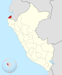
File:Location of Tumbes region.png
Appearance
Location_of_Tumbes_region.png (238 × 347 pixels, file size: 30 KB, MIME type: image/png)
File history
Click on a date/time to view the file as it appeared at that time.
| Date/Time | Thumbnail | Dimensions | User | Comment | |
|---|---|---|---|---|---|
| current | 04:56, 2 February 2005 |  | 238 × 347 (30 KB) | StarbucksFreak | Location of the Tumbes region in Peru |
File usage
The following 26 pages use this file:
- Acapulco, Peru
- Aguas Verdes
- Aguas Verdes District
- Canoas de Punta Sal District
- Casitas District
- Cañaveral, Peru
- Contralmirante Villar Province
- Corrales District
- La Cruz District, Tumbes
- Matapalo District
- Pampas de Hospital District
- Papayal District
- Punta Sal
- San Jacinto District
- San Juan de la Virgen District
- Tumbes District
- Tumbes National Reserve
- Tumbes Province
- Tumbes River
- Zarumilla
- Zarumilla District
- Zarumilla Province
- Zarumilla River
- Zorritos
- Zorritos District
- Template:Tumbes-geo-stub
Global file usage
The following other wikis use this file:
- Usage on ba.wikipedia.org
- Usage on be.wikipedia.org
- Usage on de.wikipedia.org
- Usage on fi.wikipedia.org
- Usage on fo.wikipedia.org
- Usage on id.wikipedia.org
- Usage on ja.wikipedia.org
- Usage on ka.wikipedia.org
- Usage on ko.wikipedia.org
- Usage on ms.wikipedia.org
- Usage on no.wikipedia.org
- Usage on pt.wikipedia.org
- Usage on ru.wikipedia.org
- Usage on war.wikipedia.org
- Usage on www.wikidata.org
- Usage on zh.wikipedia.org


