
File:MaryJaneWyattWhitaker-83d40m-wikiarticleSarasota.JPG
MaryJaneWyattWhitaker-83d40m-wikiarticleSarasota.JPG (400 × 424 pixels, file size: 62 KB, MIME type: image/jpeg)
| The uploader or another editor requests that a local copy of this file be kept. This image or media file may be available on the Wikimedia Commons as File:MaryJaneWyattWhitaker-83d40m-wikiarticleSarasota.JPG. While the license of this file may be compliant with the Wikimedia Commons, an editor has requested that the local copy be kept too. This file does not meet CSD F8 and should not be tagged as a Commons duplicate. If you desire to nominate it for deletion, notify the tagging editor. |
Summary
[edit]
| Description | Category:Sarasota
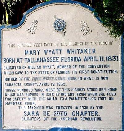
cropped and edited version of a photograph of a historic marker raised by the county government along Tamiami Trail in Sarasota near what William Whitaker named Yellow Bluffs on Sarasota Bay, which marks the location of the pioneer residence of Mary Jane Wyatt Whitaker in Sarasota on the western side of the highway and her tomb in the family cemetery on the eastern side, near Pioneer Park - she had grown up in a village named Manatee, on the river of the same name that is about thirteen miles north of Sarasota before marrying Whitaker - the cemetery is maintained by the Daughters of the American Revolution and the sign shows that the members there adopted their chapter name from an imaginary name for a founding matriarch of Sarasota (after whom a pageant developed into an annual tradition); the Whitakers returned to Yellow Bluffs, rebuilt, and prospered, living out their lives at the site and participating in the development of Sarasota |
|---|---|
| Source |
self-made from a photograph already in Wikipedia |
| Date |
December 16, 2008 |
| Author | |
| Permission (Reusing this file) |
see below
|
Licensing:
[edit]
| This work is licensed under the Creative Commons Attribution-ShareAlike 3.0 License. |
 | Permission is granted to copy, distribute and/or modify this document under the terms of the GNU Free Documentation License, Version 1.2 or any later version published by the Free Software Foundation; with no Invariant Sections, no Front-Cover Texts, and no Back-Cover Texts. |
File history
Click on a date/time to view the file as it appeared at that time.
| Date/Time | Thumbnail | Dimensions | User | Comment | |
|---|---|---|---|---|---|
| current | 19:42, 16 December 2008 | | 400 × 424 (62 KB) | 83d40m (talk | contribs) | {{Information |Description=cropped and edited version of a photograph of a historic marker raised by the county government along Tamiami Trail in Sarasota near what William Whitaker named ''Yellow Bluffs'' on Sarasota Bay, which marks the loca |
You cannot overwrite this file.