Jump to content

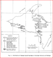
File:Michigan's Upper Peninsula's Distribution of Exposed Crystalline Rocks.PNG

Page contents not supported in other languages.
This is a file from the Wikimedia Commons
From Wikipedia, the free encyclopedia

Original file(569 × 618 pixels, file size: 61 KB, MIME type: image/png)

Summary

Description
English: Marquette, Michigan, is on the eastern side of the map, on Lake Superior. The Northern Complex is No. 1 on the map; it has three emplacements just northeast of Marquette. The Southern Complex is No. 2 on the map and has one emplacement to the just southwest of Marquette. On the Michigan-Wisconsin border are the Watersmeet Dome gneisses; they extend into Wisconsin.
Date
Source Sood, M.K.; Flower, M.F.J.; Edgar, D.E. (1984-01-01). Characterization of crystalline rocks in the Lake Superior region, USA: implications for nuclear waste isolation. [Wisconsin, Upper Peninsula of Michigan and Minnesota] (Report). OSTI ID: 5050035; Legacy ID: DE84009160. Retrieved March 31, 2010.
Author Geoscience and Engineering Group, Energy and Environmental Systems Division, Argonne National Laboratory
Permission
(Reusing this file)
On page 1 of the PDF, it says "Distribution of this document is unlimited".

Licensing

Public domain This image or media file contains material based on a work of a United States Department of the Interior employee, created as part of that person's official duties. As a work of the U.S. federal government, such work is in the public domain in the United States. See the Department of the Interior copyright policy for more information.

Captions

Add a one-line explanation of what this file represents

Items portrayed in this file

depicts

File history

Click on a date/time to view the file as it appeared at that time.

Date/TimeThumbnailDimensionsUserComment
current03:30, 2 April 2010Thumbnail for version as of 03:30, 2 April 2010569 × 618 (61 KB)Bettymnz4{{Information |Description={{en|1=={{en|The Montevideo Gneiss Complex is No. 13 on the map and occurs in two separate gerrymandering places; one has a northwesterly orientation in west-central Minnesota and the other emplacement is south of the first one
The following pages on the English Wikipedia use this file (pages on other projects are not listed):