
File:MuskegonCountyAirportFAADiagram.pdf
Size of this JPG preview of this PDF file: 390 × 599 pixels. Other resolutions: 156 × 240 pixels | 313 × 480 pixels | 806 × 1,237 pixels.
Original file (806 × 1,237 pixels, file size: 122 KB, MIME type: application/pdf)
| This is a file from the Wikimedia Commons. Information from its description page there is shown below. Commons is a freely licensed media file repository. You can help. |

|
This file was moved to Wikimedia Commons from en.wikipedia using a bot script. All source information is still present. It requires review. Additionally, there may be errors in any or all of the information fields; information on this file should not be considered reliable and the file should not be used until it has been reviewed and any needed corrections have been made. Once the review has been completed, this template should be removed. For details about this file, see below. Check now! |
Summary
| Description |
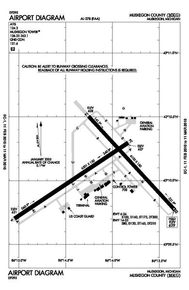
English: FAA airport diagram for Muskegon County Airport (KMKG) serving Muskegon, Michigan, United States.
Date=Effective February 11, 2010 to March 11, 2010 |
| Source | |
| Author |

|
File:MuskegonCountyAirportFAADiagram.svg is a vector version of this file. It should be used in place of this PDF file when not inferior.
File:MuskegonCountyAirportFAADiagram.pdf → File:MuskegonCountyAirportFAADiagram.svg
For more information, see Help:SVG. |
 |
Licensing
This image or file is a work of a Federal Aviation Administration employee, taken or made as part of that person's official duties. As a work of the U.S. federal government, the image is in the public domain in the United States.
|
 |
Original upload log
Transferred from en.wikipedia to Commons by Zscout370 using CommonsHelper.
The original description page was here. All following user names refer to en.wikipedia.
- 2010-02-09 19:06 Dj1997 806×1237× (125424 bytes) Reverted to version as of 18:46, 9 February 2010
- 2010-02-09 19:05 Dj1997 1075×1650× (140591 bytes)
- 2010-02-09 18:46 Dj1997 806×1237× (125424 bytes) FAA airport diagram for Muskegon County Airport (KMKG) serving Muskegon, Michigan, United States. Source=http://www.naco.faa.gov/d-tpp/1002/00278AD.PDF Date=Effective February 11, 2010 to March 11, 2010
File history
Click on a date/time to view the file as it appeared at that time.
| Date/Time | Thumbnail | Dimensions | User | Comment | |
|---|---|---|---|---|---|
| current | 05:28, 18 June 2012 |  | 806 × 1,237 (122 KB) | File Upload Bot (Magnus Manske) | Transfered from en.wikipedia by User:zscout370 using CommonsHelper |
File usage
No pages on the English Wikipedia use this file (pages on other projects are not listed).