
File:NPS grand-canyon-south-rim-map.pdf
Size of this JPG preview of this PDF file: 800 × 361 pixels. Other resolutions: 320 × 145 pixels | 640 × 289 pixels | 1,024 × 463 pixels | 1,280 × 578 pixels | 3,258 × 1,472 pixels.
Original file (3,258 × 1,472 pixels, file size: 13.71 MB, MIME type: application/pdf)
| This is a file from the Wikimedia Commons. Information from its description page there is shown below. Commons is a freely licensed media file repository. You can help. |
Summary
| Description |
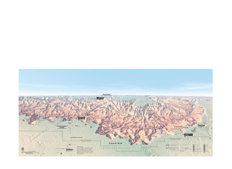
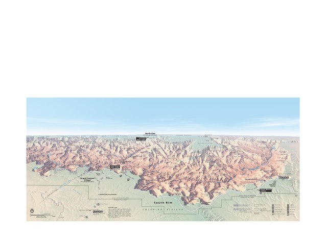
English: Main Grand Canyon South Rim map – the primary developed area of the national park featuring the most hotels and services. |
| Date | |
| Source | U.S. National Park Service (http://npmaps.com/wp-content/uploads/grand-canyon-south-rim-map.pdf) |
| Author | U.S. National Park Service, restoration/cleanup by Matt Holly |
| Other versions |
 |
Licensing
| This image or media file contains material based on a work of a National Park Service employee, created as part of that person's official duties. As a work of the U.S. federal government, such work is in the public domain in the United States. See the NPS website and NPS copyright policy for more information. |
File history
Click on a date/time to view the file as it appeared at that time.
| Date/Time | Thumbnail | Dimensions | User | Comment | |
|---|---|---|---|---|---|
| current | 23:13, 16 May 2017 |  | 3,258 × 1,472 (13.71 MB) | RKBot | =={{int:filedesc}}== {{Information |description= {{en|1=Main Grand Canyon South Rim map – the primary developed area of the national park featuring the most hotels and services.}} |date= 2013-10-24 |source= U.S. National Park Service (http://npmaps.c... |
File usage
No pages on the English Wikipedia use this file (pages on other projects are not listed).