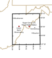
File:National Radio Quiet Zone.svg
Appearance

Size of this PNG preview of this SVG file: 541 × 600 pixels. Other resolutions: 216 × 240 pixels | 433 × 480 pixels | 692 × 768 pixels | 923 × 1,024 pixels | 1,847 × 2,048 pixels | 679 × 753 pixels.
Original file (SVG file, nominally 679 × 753 pixels, file size: 121 KB)
File history
Click on a date/time to view the file as it appeared at that time.
| Date/Time | Thumbnail | Dimensions | User | Comment | |
|---|---|---|---|---|---|
| current | 03:00, 6 October 2020 |  | 679 × 753 (121 KB) | Arlo Barnes | four years belated update |
| 04:26, 17 November 2009 |  | 679 × 753 (529 KB) | Denelson83 | Fix mis-labelling of 38°00'N as "38°30'" | |
| 08:17, 28 October 2009 |  | 679 × 753 (524 KB) | Spellcheck | Converted text to outlines | |
| 08:14, 28 October 2009 |  | 679 × 753 (355 KB) | Spellcheck | Increased font size for better thumbnail. | |
| 07:36, 28 October 2009 |  | 679 × 753 (355 KB) | Spellcheck | {{Information |Description={{en|1=The location of the United States National Radio Quiet Zone and major locations within it.}} |Source=Derivative of public-domain http://en.wikipedia.org/wiki/File:Map_of_current_Interstates.svg Information from http://www |
File usage
The following 2 pages use this file:
Global file usage
The following other wikis use this file:
- Usage on ar.wikipedia.org
- Usage on de.wikipedia.org
- Usage on fa.wikipedia.org
- Usage on fr.wikipedia.org
- Usage on it.wikipedia.org
- Usage on ja.wikipedia.org
- Usage on pt.wikipedia.org
- Usage on ru.wikipedia.org
- Usage on uk.wikipedia.org
- Usage on www.wikidata.org
- Usage on zh.wikipedia.org
