
File:Osgood rail line.jpg

Size of this preview: 800 × 450 pixels. Other resolutions: 320 × 180 pixels | 640 × 360 pixels | 1,024 × 576 pixels | 1,280 × 720 pixels | 2,816 × 1,584 pixels.
Original file (2,816 × 1,584 pixels, file size: 1.01 MB, MIME type: image/jpeg)
| This is a file from the Wikimedia Commons. Information from its description page there is shown below. Commons is a freely licensed media file repository. You can help. |
| Camera location | | View this and other nearby images on: OpenStreetMap |
|---|
| Description |
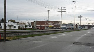
English: Overview of the former Ohio and Mississippi Railway line located along Railroad Avenue between Buckeye (the street in the distance) and Walnut Streets in Osgood, Indiana, United States. The railroad line is the subject of a state historical marker. |
||
| Date | Taken on 3 November 2012 | ||
| Source | Own work | ||
| Author | Nyttend | ||
| Permission (Reusing this file) |
|
File history
Click on a date/time to view the file as it appeared at that time.
| Date/Time | Thumbnail | Dimensions | User | Comment | |
|---|---|---|---|---|---|
| current | 00:29, 13 November 2012 | | 2,816 × 1,584 (1.01 MB) | Nyttend | {{Location|39|7|47|N|85|17|33|W}} {{Information |Description={{en|Overview of the former {{w|Ohio and Mississippi Railway}} line located along Railroad Avenue between Buckeye (the street in the distance) and Walnut Streets in {{w|Osgood, Indiana|Osgood... |
File usage
The following pages on the English Wikipedia use this file (pages on other projects are not listed):