Jump to content

File:Plover Bai.PNG

Page contents not supported in other languages.
This is a file from the Wikimedia Commons
From Wikipedia, the free encyclopedia

Original file (655 × 698 pixels, file size: 981 KB, MIME type: image/png)

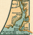
Description Map of Provideniya Bay. This was an inset detail map in Nord Polar Meer, Justhus Perthes See Atlas 1906. Details outside the inset were removed for clarity. This is useful for identifying names of geographic features.
Date (UTC)
Source
Author


This is a retouched picture, which means that it has been digitally altered from its original version. Modifications: cropped, extraneous detail outside the original inset removed. The original can be viewed here: Arctic Ocean.jpg. Modifications made by Dankarl.


Public domain

This work is in the public domain in its country of origin and other countries and areas where the copyright term is the author's life plus 70 years or fewer.


You must also include a United States public domain tag to indicate why this work is in the public domain in the United States.
This file has been identified as being free of known restrictions under copyright law, including all related and neighboring rights.

Original upload log

This image is a derivative work of the following images:

  • File:Arctic_Ocean.jpg licensed with PD-old
    • 2007-01-15T16:55:31Z Martas011 4555x3974 (6981099 Bytes) [[Category:Maps of oceans]] [[Category:Maps of the Arctic Ocean]] [[Category:Old maps of the Arctic]] Nord Polar Meer, Justhus Perthes See Atlas 1906 Good map of Arctic, inset maps of Drontheim, Drontheim fjord, Jan Mayen, B

Uploaded with derivativeFX

Captions

1906 map of Provideniya Bay

Items portrayed in this file

depicts

File history

Click on a date/time to view the file as it appeared at that time.

Date/TimeThumbnailDimensionsUserComment
current18:18, 20 February 2010Thumbnail for version as of 18:18, 20 February 2010655 × 698 (981 KB)Dankarl{{Information |Description===Map of Provideniya Bay. This was an inset detail map in Nord Polar Meer, Justhus Perthes See Atlas 1906. Details outside the inset weere removed for clarity. This is useful for identifying names of geographic features. |Sour
No pages on the English Wikipedia use this file (pages on other projects are not listed).