
File:Provmap-guadalajara.png
No higher resolution available.
Provmap-guadalajara.png (250 × 180 pixels, file size: 27 KB, MIME type: image/png)
| This is a file from the Wikimedia Commons. Information from its description page there is shown below. Commons is a freely licensed media file repository. You can help. |
Summary
| Description |
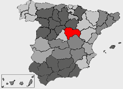
English: Province locator map of Guadalajara (created by Montrealais)
Français : Localisation de la province de Guadalajara
Italiano: Posizione della provincia |
| Date | 15 September 2003 (original upload date) |
| Source | Transferred from en.wikipedia to Commons. |
| Author | Montrealais at English Wikipedia |
Licensing
Montrealais at the English Wikipedia, the copyright holder of this work, hereby publishes it under the following license:

|
Permission is granted to copy, distribute and/or modify this document under the terms of the GNU Free Documentation License, Version 1.2 or any later version published by the Free Software Foundation; with no Invariant Sections, no Front-Cover Texts, and no Back-Cover Texts. A copy of the license is included in the section entitled GNU Free Documentation License. |
| This file is licensed under the Creative Commons Attribution-Share Alike 3.0 Unported license. | ||
| Attribution: Montrealais at the English Wikipedia | ||
| ||
| This licensing tag was added to this file as part of the GFDL licensing update. |
Original upload log
The original description page was here. All following user names refer to en.wikipedia.
- 2003-09-15 03:48 Montrealais 250×180×8 (28024 bytes) Province locator map of Guadalajara (created by Montrealais)
File history
Click on a date/time to view the file as it appeared at that time.
| Date/Time | Thumbnail | Dimensions | User | Comment | |
|---|---|---|---|---|---|
| current | 19:00, 20 December 2006 | | 250 × 180 (27 KB) | Svencb | {{Information |Description=Province locator map of Guadalajara (created by Montrealais) |Source=Originally from [http://en.wikipedia.org en.wikipedia]; description page is/was [http://en.wikipedia.org/w/index.php?title=Image%3AProvmap-guadalajara.png here |
| 22:41, 13 February 2005 |  | 250 × 180 (27 KB) | Lukius~commonswiki | From en.wikipedia |
File usage
No pages on the English Wikipedia use this file (pages on other projects are not listed).
Global file usage
The following other wikis use this file:
- Usage on de.wikipedia.org
- Usage on en.wikinews.org
- Usage on eo.wikipedia.org
- Gvadalaharo (Hispanio)
- Atienza
- Usanos
- Molina de Aragón
- Alaminos
- Alarilla
- Albalate de Zorita
- Albares
- Alcocer
- Alcolea del Pinar
- Aldeanueva de Guadalajara
- Algora
- Alhóndiga
- Alique
- Almadrones
- Almoguera
- Almonacid de Zorita
- Alocén
- Aranzueque
- Argecilla
- Armuña de Tajuña
- Atanzón
- Auñón
- Barriopedro
- Berninches
- Brihuega
- Budia
- Bujalaro
- Canredondo
- Cañizar
- Casas de San Galindo
- Caspueñas
- Castejón de Henares
- Castilforte
- Centenera
- Chillarón del Rey
- Chiloeches
- Cifuentes
- Ciruelas
- Copernal
- Driebes
- Durón
- Escamilla
- Escariche
- Escopete
- Espinosa de Henares
- Esplegares
- Fuentelencina
View more global usage of this file.