
File:S. Lankhout 1858 Map of Dordrecht.jpg

Size of this preview: 800 × 551 pixels. Other resolutions: 320 × 221 pixels | 640 × 441 pixels | 1,024 × 706 pixels | 1,280 × 882 pixels | 2,560 × 1,765 pixels | 4,777 × 3,293 pixels.
Original file (4,777 × 3,293 pixels, file size: 3.08 MB, MIME type: image/jpeg)
| This is a file from the Wikimedia Commons. Information from its description page there is shown below. Commons is a freely licensed media file repository. You can help. |
Summary
| Description |
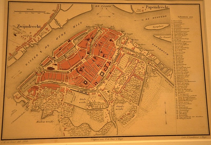
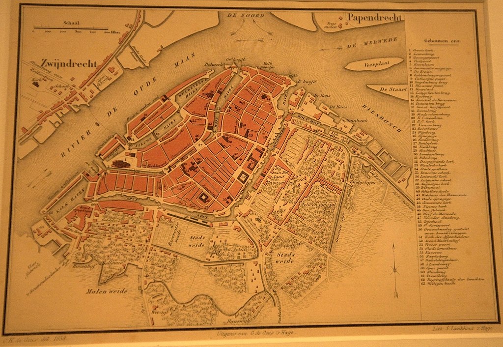
English: Photograph taken in the Dordrecht Museum. Not super clear due to poor lighting conditions and the lack of a tripod, but better than any other available published form of the map, including the exhibition's own books. The physical map is very small, only 19x13cm.
This map is notable for its depiction of two Synagogues, a feature not apparent on many other historic maps of Dordrecht. Other sources such as http://www.jhm.nl/culture-and-history/the-netherlands/zuid-holland/dordrecht suggest there was fragmentation within the local Jewish community which may have contributed to the requirement for multiple places of worship. The main Synagogue was apparently stripped and demolished. It was located at the northern edge of a square now known as Grote Markt, on the Varkemarkt street corner. The so-called Grote Markt appears to date from the 20th century, not being shown on earlier maps. Probably the Jewish area was demolished by the Nazis and replaced with this ugly square, which remains completely out of character with the surrounding buildings even today. |
| Date | |
| Source | Own work |
| Author | Pratyeka |
Licensing
I, the copyright holder of this work, hereby publish it under the following license:
This file is licensed under the Creative Commons Attribution-Share Alike 3.0 Unported license.
- You are free:
- to share – to copy, distribute and transmit the work
- to remix – to adapt the work
- Under the following conditions:
- attribution – You must give appropriate credit, provide a link to the license, and indicate if changes were made. You may do so in any reasonable manner, but not in any way that suggests the licensor endorses you or your use.
- share alike – If you remix, transform, or build upon the material, you must distribute your contributions under the same or compatible license as the original.
File history
Click on a date/time to view the file as it appeared at that time.
| Date/Time | Thumbnail | Dimensions | User | Comment | |
|---|---|---|---|---|---|
| current | 06:35, 24 July 2013 | | 4,777 × 3,293 (3.08 MB) | Pratyeka | User created page with UploadWizard |
File usage
The following pages on the English Wikipedia use this file (pages on other projects are not listed):