
File:Tsuga canadensis range map 3.png

Size of this preview: 600 × 600 pixels. Other resolutions: 240 × 240 pixels | 480 × 480 pixels | 768 × 768 pixels | 1,024 × 1,024 pixels | 2,048 × 2,048 pixels | 4,875 × 4,874 pixels.
Original file (4,875 × 4,874 pixels, file size: 389 KB, MIME type: image/png)
| This is a file from the Wikimedia Commons. Information from its description page there is shown below. Commons is a freely licensed media file repository. You can help. |
Summary
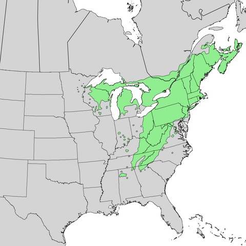
| Description | Distribution map of Tsuga canadensis — Eastern Hemlock, in the Eastern U.S. and Canada. | |||
| Date | ||||
| Source | Digital representation of "Atlas of United States Trees" by Elbert L. Little, Jr. [1] | |||
| Author | U.S. Geological Survey | |||
| Permission (Reusing this file) |
|
Original upload log
The original description page was here. All following user names refer to en.wikipedia.
- 2010-01-18 19:29 Masebrock 682×654× (126713 bytes) {{Information |Description=Range map of Eastern Hemlock (''Tsuga canadensis'') |Source=Digital representation of "Atlas of United States Trees" by Elbert L. Little, Jr. [http://esp.cr.usgs.gov/data/atlas/little/] |Date=1999 |Author=U.S. Geological Survey
File history
Click on a date/time to view the file as it appeared at that time.
| Date/Time | Thumbnail | Dimensions | User | Comment | |
|---|---|---|---|---|---|
| current | 23:51, 5 January 2014 | | 4,875 × 4,874 (389 KB) | Nonenmac | Higher resolution. no striping noise, province borders, white lakes, color matches most taxoboxes |
| 10:18, 16 October 2011 |  | 682 × 654 (124 KB) | Forstbirdo | {{Information |Description=Range map of Eastern Hemlock (''Tsuga canadensis'') |Source=Digital representation of "Atlas of United States Trees" by Elbert L. Little, Jr. [http://esp.cr.usgs.gov/data/atlas/little/] |Date=1999 |Author=U.S. Geological Survey |
File usage
The following pages on the English Wikipedia use this file (pages on other projects are not listed):
Global file usage
The following other wikis use this file:
- Usage on ar.wikipedia.org
- Usage on eo.wikipedia.org
- Usage on hu.wikipedia.org
- Usage on pms.wikipedia.org