Flosta
Flosta kommune | |
|---|---|
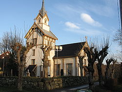
 View of the Flosta Church | |
| Coordinates: 58°31′43″N 08°56′02″E / 58.52861°N 8.93389°E | |
| Country | Norway |
| Region | Southern Norway |
| County | Aust-Agder |
| District | Østre Agder |
| Municipality ID | NO-0916 |
| Adm. Center | Kilsund |
| Area | |
| • Total | 22.8 km2 (8.8 sq mi) |
| Time zone | UTC+01:00 (CET) |
| • Summer (DST) | UTC+02:00 (CEST) |
| Created from | Dypvåg in 1902 |
| Merged into | Moland in 1962 |
Flosta (historic: Flougstad) is a former municipality in Aust-Agder county, Norway. The 22.8-square-kilometre (8.8 sq mi) municipality existed from 1902 until its dissolution in 1962. It is currently part of the municipality of Arendal in the Sørlandet region of NOrway. The administrative center of Flosta was at Staubø in the village of Kilsund. The municipality primarily encompassed the two islands of Flostaøya and Tverrdalsøya and about 9 square kilometres (3.5 sq mi) on the mainland just north of the islands including the villages of Eikeland, Borås, and Vatnebu.[1][2]
History
The municipality of Dybvaag was established on 1 January 1838 (see formannskapsdistrikt), and this municipality included all of what would later become Flosta municipality. On 1 January 1902, the islands of Flostaøya and Tverrdalsøya and some of the mainland north of the islands (population: 1,892) was separated from the municipality of Dybvaag to form the municipality of Flosta.
During the 1960s, there were many municipal mergers across Norway due to the work of the Schei Committee. On 1 January 1962, the municipalities of Stokken (population: 2,783), Austre Moland (population: 1,607), and Flosta (population: 1,205) as well as Strengereid area in Tvedestrand (population: 375), creating the new municipality of Moland. Later, on 1 January 1992, Moland (including the area of Flosta) was merged into the municipality of Arendal.[3]
Name
The name of the municipality (originally the parish and the church) comes from the old name for the island of Flostaøya (Old Norse: Flóstr) since this is where the hisotoric church is located.[4]
References
- ^ a b Kiær, Anders Nicolai; Helland, Amund; Vibe, Johan; Strøm, Boye (1904). "Flosta herred". Norges land og folk: Nedenes amt (in Norwegian). Norway: H. Aschehoug & Company. p. 168. Retrieved 2017-11-28.
- ^ Thorsnæs, Geir, ed. (2017-08-03). "Flosta". Store norske leksikon (in Norwegian). Kunnskapsforlaget. Retrieved 2017-11-28.
- ^ Jukvam, Dag (1999). "Historisk oversikt over endringer i kommune- og fylkesinndelingen" (PDF) (in Norwegian). Statistisk sentralbyrå.
{{cite journal}}: Cite journal requires|journal=(help) - ^ Rygh, Oluf (1905). Norske gaardnavne: Nedenes amt (in Norwegian) (8 ed.). Kristiania, Norge: W. C. Fabritius & sønners bogtrikkeri. p. 32.
External links
 Arendal travel guide from Wikivoyage


